Tag Archive: Makalu


Dudh Kund Pokhari

Click on photos to enlarge them

From 13  to 27 May 2016

General feelings

This adventure in the mountains had some ambitions:

  • To leave Khanbari, the big city of the Sankuwasabha district in the northeast of Nepal, joining the Solu to return to Kathmandu by Salleri in jeep.
  • To go, according to our physical fitness, towards Kongde and Dudh Kund and try the ascent of a small 6000.

But it is necessary for it to accumulate the numerous ascents: 13 877 meters, more than 44 Eiffel Towers and descents, sometimes vertiginous. We had neglected the necessary efforts to enter into the Solukhumbu, at the heart of the Sherpa Country .

The good weather will not be there everytime and the rain will prevent us from benefiting, sometimes, from the beautiful panoramas.

Carrying the tent, the burner, petrol and the food all the route for three small days of autonomy is to pay an heavy tribe. The freedom has its price and we will be rewarded by the magnificent landscapes of Dudh Kund. The low cloud ceiling will unfortunately condemn any attempt of ascent. That will happen another time!

The numerous rhododendrons forests let expect multicolored sights at spring. This period is to be favored without hesitation!

However, these 15 days will have allowed us to discover magnificent villages, outside main roads, in basic conditions sometimes, but always welcomed with broad smiles and this sense of hospitality from people who do not know the superfluous.

Preparation:

On Google Earth, with Lonely Planet and Voyage Forum. A question did not receive any answer: how to go towards the Kongde base camp is a mystery for us to be clarified. If you know, we would be pleased to learn!

Bags are less loaded that usually because we take a minimum of food (2.25Kg). We plan to get supplies at the closest places from the segments where we will be in complete autonomy. We will not find cheese in the various shops. We will content ourselves with Chinese noodle soups and with biscuits.

15.6 Kg for me and 9.5 kg for Sylvie, including the Easton 1Kg tent which will hang on during the snowstorm on Camp 1: it held correctly but ties on the double roof unstucked with the humidity, the next day in Dudh Kund! evident manufacturing defect! We will see how  the retailer reacts… Because of this defect, we would have to give up going farther!

Stove MSR XGK EX: the pump was replaced after the breakdown of October, 2015 at 5473 m. With 500ml of gasoline given in Khandbari (take care, gasoline is sold only in Tumlingtar).

Shall we eventually find reliable equipments? High prices and marks do not seem to be the panacea.

Mattress: Thermarest Néoair XLIT – Very useful

Sleeping bags: Valandré Bloody mary

Access and Budget

Oman Air is the best  and  lowest offer this year with a round trip for 475€  with a good service and short stopovers.

Internal flight to Tumlingtar with Yeti Airlines at 123 USD the one-way trip. With no problem at all. Return to Kathmandu from Phaplu in jeep. 11 hours, 1500Rs / person. Departure at 5:30am. Purchase of places in the lodges close to the Phaplu airport. The road is very beautiful on a long part of the route. We arrive (we have to leave also the same place) to the point 27.718078 85.347132, close to the Tribhuvan airport and to the Buddhanath. Advise: buy 1 additional place to avoid being 4 on a seat for 3.

Less than 900€ spent on 30 days, included souvenirs. Between 1500 and 4000Rs a day for two. The prices indicated in the logbook will be generally given for two people.

Situation

Situation trek Khandbari Phaplu

Timetable

agenda trek Khandbari Phaplu

Altitude depending on distance

altitude distance trek Khandbari Phaplu

Altitude at Night

altitude soir trek Khandbari Phaplu

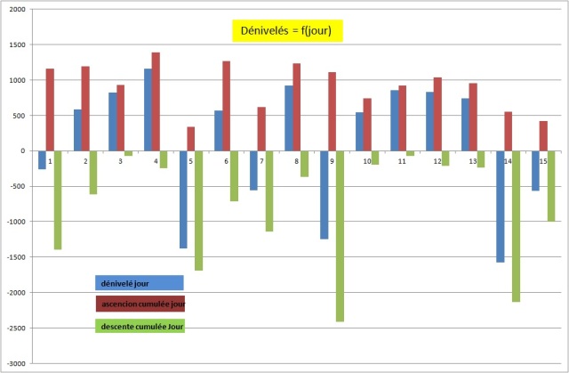
Daily Height Difference 
dénivelés jour trek Khandbari Phaplu

This year, the daily cumulated altitude differences are calculated from the GPS traces. The main difficulty of this trek consists in the ascents and descents for crossing the valleys.

GPS Traces et waypoints:

Traces are defined with a point for 30m to avoid the saturation of the GPS memory. They are in free access on Wikiloc, with some significant waypoints, indicated in this logbook. All Waypoints are given in an Excel sheet  in GPS/tableur Spreadsheets

Our new GPS GARMIN ETREX 10 is great. It uses fewer batteries than the precedent: 2 AA approximately every 5-6 days. It can be linked with the computer to copy the traces and waypoints.

The waypoints on the excel sheet were corrected after the trek, where it was necessary. The distances between waypoints are on the other hand approximate. The daily distances are exact. Finally, and as usual, our paths are not necessarily the best. They can change in time, the collapses and the construction of new roads. All trekkers remain responsible for their own routes.

To be noted:

The new road after Kattike Ghat go by an unnecessary pass. It must be possible to by-pass it by going along the Irkhuwa valley,  as it is indicated on the map (Jiri Pikey Peak 1:125 000).
We voluntarily avoided the center of Bung, by-passing it by the right.
We followed the indications on the map by going from Panggom to Taksindu via Bupsa. It’s a big mistake because this route requires half an additional day of walking in inconfortable ascent. Unless going to Lukla, the best is to come down directly towards Karikhola from Panggom. The track is physically visible, but absent on the map!

Logbook:

Friday 13th May, From Khandbari to Chalise (970m) wp K14

Awake 5h15, t=21°c, departure 7h15, Arrived 17h, 22km in 9h45, cumul ascent 1160 m, cumul descent 1398 m

This is not so simple to go out of a city by foot from a small track, even with the GPS. Our friends in Khandbari suggested  to putting us on the good path. But it is a question of pride… We also want to escape in the early hours to walk as much as possible without rain. After some hesitations, we begin the big descent towards the Arun river. We join a track which has to connect Tumlingtar to the upstream of Arun (probably on the bank, opposite to Kattike, just before the monkey bridge which drives to this village).
Solu 2016 joli maison vers Kattike

We cross very beautiful villages and find sometimes small restaurants. A drizzle begins to fall by 9:30 am which stops also quickly. The way is pleasant and we lunch in Kattike, on the other bank of the Arun. We understand there would be 3 jeeps a day until Ghote bazar (one-way trip at 500 Rs ?). The only jeeps we see have their hoods wide open and they seem to have given up their ghost. We don’t moreover know from where they can come. We continue by foot and, as usual when a new road has been opened, the track is difficult to find. To follow the road would mean making considerable detours. Solu 2016 descente vers l'Arun
Solu 2016 rizière vers Chalise

We cross an unforeseen pass at 928m. We did not find any alternative, that one, in particular, which was to follow the left bank of the Arun then of the Irkuwa khola. We stop at Chalise. The first house, in the entrance of the small village, offers the hospitality. There is no guesthouse here. We take a basic shower with the small water pipe, in the garden. And this evening, it will be dalbath, of course. (800Rs with the overnight stay and Tibetan tea)

Solu 2016 incontournable dalbath à Chalise       Solu 2016 proprio de Chalise

Saturday 14th May, from Chalise to Tendo (1372 m)

Awake 5h30, t=20°c, depart 6h30, Arrived 17h, 16.5km in 10h30, cumul ascent 1194 m, cumul descent 617 m

Solu 2016 vers Tendo

It rained a large part of the night and it is only at dawn that the drumming of drops on the roof sheet steel stopped. The weather is clear at the sunrise. We have a Tibetan tea for the breakfast and we finish the rests of the day before: bananas and rootis. The way rises at first regularly. It is necessary to be careful to cut the new road at the good moment to avoid endless detours. We quickly arrive to the village preceding Gothe bazar, Tabutar. This is, in fact, the terminus of the 4-wheeled vehicles. We are happy to leave this kind of civilization. There is a nice guesthouse in Gothe bazar, the first one since Kattike. After Gothe bazar, the way becomes a narrow track. We stop several times to take a tea or a mango juice in small taverns.

Solu 2016 vers Tendo 3Solu 2016 vers Tendo 2Solu 2016 vers Tendo 4

We arrive to Tendo under a flood of rain. Fortunately, we find a kind soul to welcome us: there is not of guesthouse in this village and before Phedi.

Sunday 15th May, from Tendo to Djobari (2215 m) wp62

Awake 5:50, t=18°c, departure 7:10, Arrival 12h, 4.2km in 4:50, cumul ascent 931 m, cumul descent 75 m

It rained all night long and it’s always raining upon awakening. We do not hurry. Furthermore, we are tired by the previous two days of walking. The rain stops during the breakfast (tea and biscuits). It takes less than one hour and a half to join Phedi where there is two lodges in the entrance of the village. We do not take the precaution to fill our bottles of water before the big ascent and we will have to beg water on the way. We arrive at Djobari early but we decide to take some rest in a small lodge the owner of which it is necessary to find before being able to settle down. We are rewarded for the efforts of the morning with a beer and biscuits for the lunch.

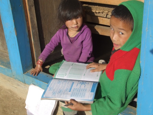
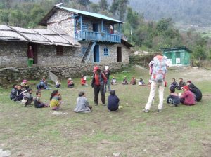
The school is in reconstruction close to the lodge. The damages are probably a consequence of the April, 2015 earthquake. Many houses are damaged, padlocked or in reconstruction on the road. The villagers assemble its frame while the children attend their class in a temporary building. The class is disrupted by our arrival and we are transformed into local and improvised entertainment.


Solu 2016 vers Djobari 1

Solu 2016 vers Djobari 2Solu 2016 vers Djobari 3

Monday 16 May, from Djobari to Salpa (3357m) wp67

Awake 5:40, t=15°c, departure 7:20, Arrival 3:45, 8.4 km en 8h30, cumul ascent 1394 m, cumul descent 247 m

Solu 2016 vers Salpa 1

First change of batteries for the GPS. The weather is correct this morning and we take our time for the breakfast with tea and biscuits bought to the store of the lodge. I pay 1800Rs for all: night, beer, dalbath, apple spirit, biscuits, mango juice and tea.

The village extends in height and we discover another lodge, more centered, with a real restaurant. We’ll not find more water before Salpa as we pass by long crests and the soil becomes sandy.

Solu 2016 vers Salpa 3

At middle way (place called Kharka on the map), we go on by the right, according to the advice of several locals and against the indication of the GPS. This detour makes us pass by the lake while the map indicates a main way directly to Salpa. It has maybe disappeared in a collapse? A thunderstorm surprises us at the beginning of the detour and we just have time to protect ourselves in a hut-cowshed. We hesitate to return towards the abandoned village (Kharka) or to try our luck towards the lake to camp, less than a kilometer from there in theory. We cross an impressive rhododendrons forest. Some are still in bloom. The view must be magic in spring.

We have no more than one liter of water when we discover, instead of a lake, a totally dry basin on a sandy bed with some huts (WP65). It is almost 3 am. Impossible to stay. A local indicates that Salpa is just on the other side of an almost vertical pass. We decide to go. The sacred lake is on the other side of the pass, reached in half an hour. It is incised and offers no panorama. Some workers work on the arrangement of its sacred banks. The lack is invaded by mists and does not tempt us to establish a camp there.

Solu 2016 vers Salpa 4 Solu 2016 vers Salpa 5

We discover Salpa, based on a crest. The village seems abandoned and there is no tap water. Salpa seems to have for only vocation to welcome the pilgrims. There is fortunately an open building. The owner offers us the shelter in a very basic shed where will pile up porters and her family during the night.

Tuesday 17th May, from Salpa to Gudel (1975 m) wp70

Awake 5:45, t=6°c, departture 7:15, Arrival 3:45pm, 14.7 km in 8h30, cumul ascent 337 m, cumul descent 1691 mSolu 2016 vers Gudel

The night was interrupted by noisy arrivals of porters. We gave up blanquets, openly sticky. The owner, remaining a businesswoman, asks us 1800Rs of which 1200Rs for the dalbath!

Alerted in the early hours by more or less harmonious sounds, we attend a procession leaving from the big gompa in front of our shelter, led by a young man who wears a feathers headdress . I am surprised, seeing the pilgrims taking him in video and in photos (I make nothing else).

Long life to all religiosities when they do not incite either to the hatred or to the violence!

It was not question of the slightest toiletry in Salpa and we stop near a torrent to wash ourselves and for a small laundry. Wp68. The sun is with us for our happiness. This hillside is also very bucolic, papered with rhododendrons.

Solu 2016 vers Gudel 2

Solu 2016 vers Gudel 1

A rusty panel indicates Sanam and an inhabitant recommends us to continue in this direction. We prefer to go on by the valley to avoid a new useless pass. The way in the valley is less taken and sometime more difficult to find. The weather remains clear until 2:30 pm, as a Chilean doubles us as a racing car. It is our first trekker in 4 days and even the first one since we are in Solu and Makalu.

A thunderstorm arrives while we discuss. Panchos, frequently used up to there, areuseless because of the violent wind. It is time to arrive to Gudel before being dipped. The lodge which opens to us, Kopila Guesthouse, is perfectly clean. Never seen at this point before!

Wednesday 18th May from Gudel to Khiraule (2539 m) wp72

Awake 5:30, t=14°c, departure 6:40, Arrival 5:30pm, 9.4 km in 10h50, cumul ascent 1264 m, cumul descent 712 m

Solu 2016 vers Kiraule 5

Everything began correctly with a breakfast as worthy as in Khumbu. Sylvie is brutally struck by a tourista while we begin the descent. We stop in emergency for half an hour. The rhythm of the walking will feel the effects of it during the day. We abandon the main path to avoid the center of Gudel by going on the left (would be better to try by the right). The crossing of the small hamlets is very nice but the path often gets lost in the terraces of the fields. We ask several times for our direction to the inhabitants, a little bit surprised seeing us walking there…

Solu 2016 vers Kiraule 1Solu 2016 vers Kiraule 4

We stop for the lunch in a magnificent lodge: Panch Pokhari Lodge wp71. We take our time (1:30) to appreciate this luxurious place. We are far from the Makalu basic stopping places. We complete our endless rise towards Khiraule, slowly and by enjoying the tranquillity and the bucolic charm of the region. A small paradise opens to us and we stop more often than to get back our breath, to take advantage of what the way offers.

We arrive late at the lodge. it is adjacent to a temple in the circular temenos, composed of manis and lined with old pines. Magnificent!

Solu 2016 vers Kiraule 6

The night has felt when we go out of the dining room, fed of dalbath and raksi. The panorama, as far as go our looks, is papered with small lights, so many houses, as stars, uncountable. The place is silent and inhale the serenity. We didn’t rose for nothing.

The night is a bit expensive, 500Rs, but as we are near the Paradise, it doesn’t matter.

thursday 19th May, from Khiraule to Inkhu khola (1982 m) wp74

Awake 6am, t=8°c, departure 8am, Arrival 3:15pm, 8.3 km en 7h15, cumul ascent 615 m, cumul descent 1136 m

Solu 2016 vers Inkhu khola 1

It rained a large part of the night after the sunny day of yesterday. This morning is cloudy and we have to join two impressive stupas which guard the pass. We cross fog patches. The descent towards Inkhu khola is difficult. We cross Nadjingsur, in a plateau, which possesses three correct lodges. We arrive to the bridge at about 3 pm and we have no courage to raise the 700m reaching Sibuje. We find a rustic lodge just after the bridge possessing a shower! (1800Rs for dinner, bed and breakfast)

Solu 2016 vers Inkhu khola 2Solu 2016 vers Inkhu khola 3

The Inkhu khola gorges are spectacular. The weather is unfortunately very cloudy and showers begin to fall at 4pm.

Solu 2016 vers Inkhu khola 4

Friday 20th May, from Inkhu khola to Panggom (2900m) wp78

Awake 6am, t=15°c, departure 7:30, Arrival 5:20pm, 7.1 km in 7h50, cumul ascent 1234 m, cumul descent 365 m

It rained all night long and it go on in the morning. Ponchos have never served so much! We stop to Sibuje in the fog ( wp75 ) for the lunch at 10:50 am. The ascent exhausted us while we are only at the middle of the way to the top. We refuel with a soup in noodles, an omelet and a tea (800Rs. These stops are so many opportunities to share the everyday life of the Nepalese families. A shower sticks us more than one hour. We leave in the fog. There are good lodges there ( wp76 ).

A shower surprises us again and we continue under the ponchos…

Solu 2016 vers Panggom 1

A panel indicates « Pangome Gompa » and we try to go there, against the indications of the GPS. We turn back because we have no idea where it can lead us. We will discover this Gompa on a height by arriving at Panggom. As the deviation leads to it, it was possible to go on the fork to pass by the gompa on the way to join Panggom.

Solu 2016 vers Panggom 2

The lodge (Himalaya Trekkers) which welcomes us is new and well maintained. It possesses even a hot shower! We are served with a correct dalbath and an excellent raksi with millet,  » barli  » and quince? Diuretic in any case! 2000Rs for the dinner the overnight stay and the breakfast.

A dance gets ready with brash young girls. We are informed but not invited 😉 In a so small village, a such concentration seems surprising. These girls are probably living in a hostel adjacent to the lodge. It would mean that they go to an Hillary school?  His foundation created a lot of these schools in the region. In this case, we could assert that it is a big success.

 Saturday 21th May, from Panggom to Jubhing (1656 m) wp 79

Awake 6:30, departure 7:30, Arrival 5pm, 13.1 km in 9h30, cumul ascent 1115 m, cumul descent 2416 m

Solu 2016 vers Jubhing 1

We pick in our reserves for the breakfast because the manager has messages to send and does not have too much time for taking care of us … While we are already on the way towards Bupsa, she shows from a window, that another way go towards Taksindu. We do not take this advice into account because the map indicates only one way, passing through Bupsa. The descent is soon transformed into rather stiff, illogical ascent as we have to join the valley. Sylvie takes one foot in a root while she is sliding. All her leg holds her weight and that of her bag in twisting. The first pain blurred, all the leg remains painful. She decides to leave slowly and by limping. I take her bag. We are fortunately close to Bupsa.

Solu 2016 vers Jubhing 2Solu 2016 vers Jubhing 3

The road towards Bupsa leads to Lukla and Namche. It is a big bend to go towards Taksindu because it is pointedly necessary to dive into the valley of Kharikhola. We stop in the first lodge, very clean. The owner gives us an anti inflammatory cream and recommends not to make anymore effort today. Meal 850Rs. Sylvie getting better, we leave towards Taksindu on the important track linking Jiri and Phaplu to Namche. The convoys of mules pass almost continously. The way is papered with stinking and slippery dung. It is sometimes necessary to push away animals with the stick not to be pushed aside. To complete the pleasure, it’s a Buddhist national holiday today. Repetitive speeches, spread by loudspeakers, accompany us a big part of the afternoon. We stop to Jubhing. Lodges, here, has no more the quality of those met since a few days.

Solu 2016 vers Jubhing 4

Sunday 22 May, from Jubhing to Nunthala (2198 m) wp80

Awake 5:45, t= 17°c, departure 7:20, Arrivl noon, 5.7 km in 5h40, cumul ascent 741 m, cumul descente 192 m

Solu 2016 vers Nunthala 2

The previous day cost us  1250 Rs for lunch and  1650 Rs for bed and dinner. The average of the spending is in average 25 – 26€/day

The sky is clear this morning and we can perceive some high summits of Khumbu. The walking begins with a little convenient descent in the dung of mules towards the Dudh khola. Then begin the ascent, under the sun, sawing our legs. But Sylvie’s knees gets better.

The batteries of the GPS are changed for the second time at 11:10 am.

Solu 2016 vers Nunthala 3

Solu 2016 vers Nunthala 5

We arrive to Nunthala for the lunch (magnificent Himalayan Trekker Lodge). The village is particularly beautiful and clean. We would almost imagine we are in Switzerland. People are smiling and it tempts us to stay. The decision is taken during the lunch: after noon will be a resting time before the next 4 days of ascent. We are go about in the main street and take back our strengths.

Solu 2016 vers Nunthala 6

Monday 23th May, from Nunthala to Taksindu la (3053 m) wp DK01

Awake 5:30, t= 16°c, departure 6:50, Arrival 11:15, 5.7 km in 4h35, cumul ascent 926 m, cumul descent 70 m

Solu 2016 vers Taksindu la 3

Is Nunthala endowed of an Hillary School? Big buildings overhang the village, as we had seen in Panggom. We go up without any trouble by comparison with yesterday. The sun is softened by a light mist. The panorama is unfortunately partially filled by clouds. The view remains magnificent. After investigation in Taksindu, we decide to continue until Taksindu la where is a recent lodge and the starting point for Dudh Kund, the Milky Lake.

Solu 2016 vers Taksindu la 1

We are now in the mist and Sylvie would eat a chicken with her feathers (she says). A new free afternoon for rest  in a very comfortable lodge.

Solu 2016 vers Taksindu la 4        Solu 2016 vers Taksindu la 2

Tuesday 24th May, from Taksindu la to Camp 1 (3884 m) wp 81

Awake 5:30, t= 9°c, departure 7:30, Arrival 15h15, 8.3 km en 7h45, cumul ascension 1037 m, cumul descent 210 m

Solu 2016 vers camp 1 1JPG

The departure is in the fog. Sylvie grumbles because she don’t want to leave in this bad weather. I hope that it will get up with the ascent. The way is very bucolic and well marked . It crosses a beautiful rhododendrons forest in the first part which becomes mixed after. We have a lunch when two young Nepalese double us: they join a camp of high pastures. They are the only human beings that we’ll meet during these three days. Rain begins by 2 pm.

Solu 2016 vers camp 1 2

We see beautiful massifs of yellow rhododendrons, still with beautiful flowers at these altitudes.

We made more or less half of the path to Dudh Kund when we find a correct place for a camp. It is always raining and we settle the tent in these difficult conditions. It will be necessary to content ourselves with the remaining water from Taksindu la because we haven’t found any source on the path.

Solu 2016 vers camp 1 3

Wednesday 25th May, from Camp 1 to Dudh Kund pokhari (4626 m) wp 83

Awake 6am, t= 0°c, departure 7:30, Arrival 3:20pm, 9.7 km in 8h15, cumul ascent 954 m, cumul descent 237 m

Solu 2016 vers Dudh Kund 1

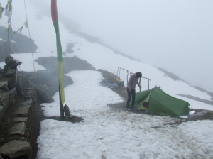
The rain had stopped at night to start up again with renewed vigor. It is accompanied with gusts of wind then snow. This is the big storm. The temperature falls brutally. We are afraid that the tent flies away and that bags, protected by ponchos, fall in the ravine. I get up before the day rise to verify the installation. The spectacle is Dantesque with a moon quarter and some visible stars in patches of clear sky, and, far off, with the cleared big massifs, overhung by a strange black coat. I remove the snow accumulating on the double roof, making both walls contact themself. I go back to bed hoping that the storm will quickly stop.

When the weather calms down, the sky is totally cleaned. A carpet of snow recovers the surroundings. After the breakfast, Sylvie is not convinced to continue. I decide anyways to go on at all costs, now so close to the goal. She should come down easily to Taksindu. The perspective of the forest crossing makes her have a change of mind.

Solu 2016 vers Dudh Kund 3

First water source at wp 82. Sylvie is particularly slow and I begin to doubt our capacities to reach to the lake today. I decide to carry her bag. I ascent on approximately 500m  with 28 kg and some cramps will make me suffer at the stage!

Solu 2016 vers Dudh Kund 4

The weather quickly gets blocked with the rise of mists caused by the heat of the first sunrays. Snowing begins but there is no thunderstorm. The mist withdraws from time to time to make us perceive majestic summits and so close, a gigantic cliffs. We arrive, exhausted, to Dudh Kund. Surprised! There is no lake but an alignment of low walls. I forgot that the lake is further north. It is necessary to continue…

The lake is smaller than I thought. Its level lowered a lot as the various strata left on its banks show. The massifs appear by intermittence. We settle the tent on an small protected area of fine sand. 

Solu 2016 vers Dudh Kund 5

Thursady 26th May, from Dudh Kund to Taksindu la

Awake 6:00, t= 7°c, departure 9:00, Arrival 5:35pm, 17.6 km en 8h35, cumul ascent 554 m, cumul descent 2136 m

Dudh Kund Pokhari

The mountains did not appear in the evening and it snowed this night. The temperature remains however too high to have a clear and dry time. We dry the bags and affairs in the shy sun rays morning. I walk to get the rare moments when the landscapes appears from the mist. The place is magnificent. I collect some old coins on the banks of the lake.

Solu 2016 Dudh Kund 1Solu 2016 Dudh Kund 2 Solu 2016 Dudh Kund 3 Solu 2016 Dudh Kund 4 Solu 2016 Dudh Kund 5

I take advantage of our stay to locate the possible passages to rise on a crest or on a summit. It will be a waste of time for this time: the weather is far too unstable to be able to continue. The weather quickly goes bad. We decide to come down, again in the fog, and occasionally in the rain. We are happy to seek refuge in our lodge of Taksindu la.

Friday 27th May, from Taksindu la to Phaplu (2490 m) wp 84

Awake 6:30, t= 14°c, departture 8:30, Arrival 1:30pm, 14.7 km in 5h, cumul ascent 421 m, cumul descente 997 m

Solu 2016 vers Phaplu 1

We take our time this morning. The weather is sunny,  even if the massifs are already in the clouds. We have no regret to have shortened our stay in altitude. The road from Taksindu, is carriageable, at least by tractors and motorcycles. It is necessary to pay attention not to leave the old track which is frequently cut,  to avoid monstrous bends. The way crosses very attractive forests of hundred-year-old pines.

Solu 2016 vers Phaplu 2

Solu 2016 vers Phaplu 3Solu 2016 vers Phaplu 4

Solu 2016 vers Phaplu 5

The trek ends to Phaplu, a little bit glaucous city, as all the border cities .

Solu 2016 vers Phaplu 6

We book the return jeep in the lodge. Meeting at 5 am for a precise departure at 5:30 am.


DSCF3358

Pic 7 et Isuwa la partiellement cachée sur la droite. Photo prise en Octobre 2015 au niveau de shersong

Nous pourrons échanger avec ceux qui sont intéressés par ce projet et, notamment sur les éléments objectifs pour construire et affiner le trajet. 

Objectif:

Joindre la vallée d’Isuwa à partir de Tashigaon et trouver un passage sur sa rive gauche vers le col d’Isuwa. Franchir ce col pour rejoindre le camp de base du Makalu dans  la vallée du Barun.

Mode Opératoire :

Plus de 33 kilomètres à partir de Tashigaon jusqu’au col d’Isuwa et cela sans aucun chemin apparent sur 28 km. Possible, impossible? Je n’en ai aucune idée avant de partir. J’ai vu qu’un trekkeur a laissé des photos géolocalisées sur une petite partie du chemin. En admettant qu’elles soient correctement positionnées, un segment de plus de 10 kilomètres doit être défriché avant de le rejoindre.

situation-tashigaon-isuwa

situation Tashigaon Isuwa MBC

De Tashigaon (2200m) , il faudra remonter avec un sac à dos de 18 à 20kg jusqu’à la crête qui mène à Kongma.

J’avais repéré un embranchement de chemin peu fréquenté en 2013 et 2014 pour s’enfoncer dans la forêt en descente au point bas de la crête (M35 = N 27.6456, E 87.2117, Altitude 3204m). Je ne sais pas si cet embranchement se poursuit vers Isuwa la. C’est mon espoir. Comme c’est mon espoir de rencontrer un terrain à peu près continu, sans trop de failles ou de blocs de roches infranchissables. Les difficultés seront au mieux nombreuses. La pente a été calculée et reste acceptable, en apparence, jusqu’au camp de base.

Je prévois 3 jours pour rejoindre un camp de base que j’établis à N 27.758543, E 87.04710, 4410m. De là et si tout va bien, il me sera possible d’accéder au col d’Isuwa à 5419m soit un dénivelé de 1000m qu’il faudrait monter en deux jours.

Un total de 5 jours est donc nécessaire a minima. Prévoir une semaine.

Un repérage sur Google Earth me fait penser que la rive droite est plus praticable mais nécessite de pouvoir traverser l’Isuwa khola. Des témoignages confirment ce sentiment à Tashigaon. Personne n’est capable de confirmer cependant s’il est possible de rejoindre Isuwa la par Tashigaon. Quel sera le débit d’Isuwa khola? Y-a-t-il des troncs d’arbres couchés en travers du torrent pour le traverser, comme j’ai pu voir sur une photo, mais beaucoup plus en amont? Je touche ici à la vraie aventure: ouvrir un chemin sur plusieurs dizaines de kilomètres. Elle peut conduire à un échec rapide et sans appel car l’entrée classique dans la vallée se fait par l’autre rive beaucoup plus en aval et plus en altitude.

D’après GE, la vue à partir du col d’Isuwa est vraiment extraordinaire et si la tentative réussit, ce serait une grande victoire par le gain d’une expertise importante pour de futurs treks de bons niveaux et originaux dans la région. En effet, de la passe d’Isuwa, tout est permis, en particulier rejoindre le Camp de base du Makalu, l’extraordinaire virée vers le Kamape ri, le Sherpani, West pass et le Khumbu, effectuer une boucle Tashigaon Isuwa la, MBC, Kangle, Tashigaon plutôt que l’antenne traditionnelle par la seule et superbe vallée du Barun.

Bibliographie:

Très pauvre pour l’instant.

Aucune trace n’est enregistrée sur Wikiloc actuellement.

Un forum russe donne beaucoup d’informations précieuses pour le passage du col, dans les 2 sens avec photos à l’appui. Voir Isuwa la.doc. A partir de ces données, les WP pourraient être assez précisément positionnés.


From Num to the East Pass’ Belvedere

From 7 to 26 May 2014

DSCF1634

 Click photos to enlarge them

GPS points in Annex and via GPS/Tableurs – Spreadsheets

Objectives :

After the forced stop to Kongma in April, 2013, because of the late snowfalls having blocked the

access to Shipton La, I organize a new trip towards Makalu, 5th summit of the world throning in 8434m.

The objective is to by-pass it until « East Pass » at 6150m, full stop of the project, to have it just 2300m up, in front of me.

Beside the meetings with our friends of Khandbari, Seduwa and Chyaksa danda, it is a ballad in 17 days with a total difference of altitude of 5400m, on a round trip distance of 130km.


Summary and Introduction:

Valleys and crests leading to the monsters of Makalu’s high mountains do not deny their reputation: the sky will be hardly blocked, up to the Base camp of Makalu (MBC). The rain will sometimes be present at the end of morning. Going up, the weather clears up to give way to a perfectly crystal clear sky during my four days and three nights of isolation after MBC. This respite will plunge me in a fabulous universe, which will mark my dreams as much as my shins: the trip is dangerous on a big part of the route, without path in the masses of fallen granit rocks of sometimes several hundred kilos in unstable equilibrium.

I won’t go to East Pass, ultimate purpose of this trek because enormous and inescapable glacier preceding it, with no visible track. The risks are too big. I shall contemplate it of my improvised belvedere at 5850m, big consolation prize …

With three foreign walkers met in three weeks, we can say that this trek is confidential. This Sherpa’s region would be worth nevertheless being better known, so warm than it is not need to know how to speak their language to exchange and spend long and unforgettable evenings by sharing Rocksi without moderation (Arack in Sherpa: alcohol of millet distilled once) and Sucuti (dried meat of yak recooked in the wood fire) and the unchangeable dalbath.

It is precious to discover their culture mixed with cheerfulness, innocence and frankness…hoping that it remains for a long time hung on on the sublime hillsides of their sacred mountains.

Preparation :

The route and the stays are positioned with the help of Google Earth ( GE ) and points entered in the Garmin GPS.

5 Days of autonomy are planned (2.6kg of food + tent).

The total taken weight is 18kg, including the water, the gasoline and the camera bag. Backpack: Gregory Wander 70; tent: Vaudé Power Lizard SUL 2 places; stove: MSR XGK EX with 400ml (100ml will be enough) of gasoline bought in a petrol station in Kathmandu; mattress: Thermarest Néoair XLIT

Sleeping bags: Valandré Bloody mary

I am accompanied with my friends of Friends of Nature to Tashigaon then alone up to the East Pass’ Belvedere.

Situation and route:

DSCF1373 situation


DSCF1373 trajet

Access :

Turkish Airlines, “best European company”, will not contradict its recent reputation. For 584€, it is the most direct access  to KTM. The ticket KTM Tumlingtar was bought by internet, it is a considerable novelty. From Tumlingtar to Num, jeeps leave when they are full (14 passengers): 150Rs to Khandbari (a small hour) then 600Rs to Num (4-5 hours)

A road is under construction to continue, as it is said to Tashigaon (not too fast!)


Budget :

Flights international: 584€, national KTM Tumlingtar: 184€, visa, entrance fee in the park, the accommodations and the meal in KTM and during trek: 420€, that is all in all less than 1188€


Agenda :

agenda

Height at Night :

Altitude à l'étape

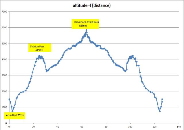
altitude distance


Difference altitude / day :

dénivelé jour

The trek from day to day

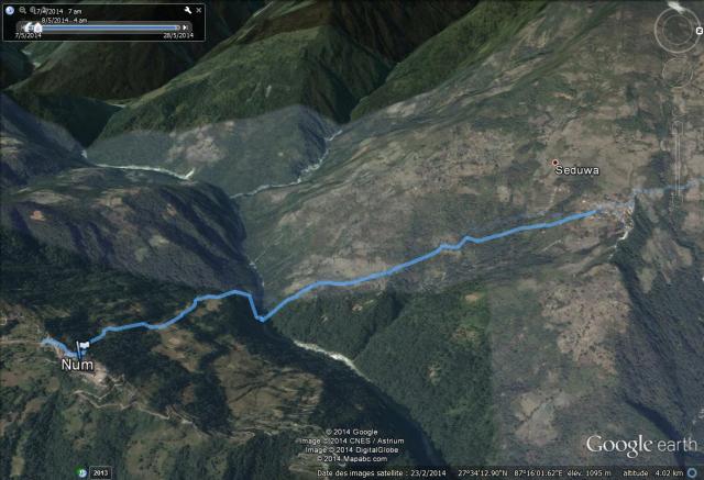
Wednesday, 7 May – from Num to Seduwa

Descent  49m;  6km in 4:30; altitude at night: 1572m

DSCF1406a Num Seduwa


It is necessary to take back the good habits after 3 hours of expectation and pay the last seat which remained desperately empty to be finally able to leave. Finally 4 hours of jeep between Khandbari and Num on an chaotic track opened five years ago. This time, we are lucky because the rain does not fall.

   DSCF1406DSCF1406b

The trek begins only towards 1 pm after an inescapable dalbath in Num, giving strength enough for the route. I have to get used again to the bag, which destabilizes me at every false step.

The descent from Num is vertiginous. It avoids a real cliff which falls in the Arun’s bed.

I have difficulty following Sanjaya, been used to the path. We arrive shortly before the nightfall in Seduwa. Our friends wait for us there and reunion  will be celebrated  with the local Tongba (beer of millet which continues to ferment with the successive additions of hot water in the mixture).

A turista takes shape in perspective. It is unfortunately a good idea to avoid Tongba and  Chang unless if the water being used is enough boiled or was chemically treated before.

Thursday 8 and Friday 9 – Interruption of the trek.

Stay at Friends Of Nature’s farm between Chyaksa and Tashigaon

It is an ideal opportunity to enter Sherpa’s houses and share their everyday life. My friends translate but it is not need for words to appreciate the tchang prepared by the hostess in front of us. The principle is  to never let glasses empty. They have to be always full. We also attend the distillation of this beverage which will take the name of Rocksi to Arack or still Local. The cold source is situated in the superior pot and must be regularly changed to allow the condensation of the distillate. Contrary to Tchang and Tomba, this drink is completely safe for the digestive system.

In the farm of Friends of Nature, we shall also kill the chicken which will improve considerably the dalbath. On these lands, the experiment of the kiwi culture began in spring. It will soon be a source of vitamins for all the populations of the valley (approximately 4000 people)

DSCF1410DSCF1446

DSCF1447

Saturday 10  May – from Seduwa  to Tashigaon

Ascent: 628m 8.45km . altitude at night: 2200m

DSCF1407 Seduwa Tashigaon

We continue to walk in rice fields and I discover my first leeches. They hang on to soles or to clothes when we touch them. They infiltrate then under clothes to quietly drink the blood. They are plenty between Seduwa and Tashigaon but I’ll not see them any more afterward. To avoid them, it is necessary to walk at maximum on stones and avoid the edges of paths.

The country remains peaceful and hot.The overcast weather does not allow to distinguish the surrounding mountains.

In Tashigaon, we celebrate my solo departure the next day with a lot of beers. The manager of the park warns me on the difficulties of the route and makes me understand that it can be wise not to go up to the Base camp. I note it but I burn with impatience to get stuck with myself finally in the real difficulties of the route.

DSCF1487

DSCF1470

Sunday, 11 May – from Tashigaon to Kongma

 Up at 5 20, departure at 6 20. Arrived at 13 45, Ascent: 1429m 6.45km

altitude at night: 3629m

DSCF1495 Tashigaon Kongma

The ascent from Tashigaon to Kongma is practically continuous, in the forest. I take advantage for the last day in tropical atmosphere. Birds answer in the infinity. The last rhododendrons illuminate with red brightness the path. The steeply track is an obstacle. You should not try to go faster than of reason. The air is not still lacking but the path already dilutes in separated series of stairs on which feet, still clumsy, look for an often uncertain support. The ascent is long. It is necessary to be patient. It is the price to be paid to escape, maybe, the mist which surrounds anything when the sun begins to give.

There are few houses on the way, some farms among which one allows the provisioning and even a lunch when it is opened.

I meet a Sherpa  with a high-alcohol breath. I shall learn afterward that they find the energy there to carry their heavy loads.

I find Kongma without the snow setting we had left, there is a little more than one year. The almost vertical walls I cross today were then covered with snow. I feel more at ease.


 DSCF1497

 DSCF1509

Monday, 12 May – In Kongma, acclimatization day

I hesitate to stay but I need to be reasonable. The good weather invites me nevertheless to leave. I met the day before my first trekker. He comes down from Makalu and indicates a beautiful antenna from Shersong: the crest to be taken staying on the left to overhang the base camp at 5300m or a bit more in the direction of the peak 3. In clear weather, by settling there we can discover simultaneously Makalu, Everest, Lhotse and Kanchenjunga. I would not go this time if I can go towards the East Pass which is the objective of my project.

The day is long in Kongma. I take advantage of it to do my first laundry and have an a little less superficial wash. It is necessary to recognize that it is not easy to remain a little bit clean on this route. From Tashigaon included, there is no water source a little isolated except the possible toilet …

I order chapatis for the breakfast. Bad idea because the owner understands chiapati. She begins to prepare some Tibetan tea. I won’t confuse anymore  » chiapati  » Tibetan tea and  » tchapati  » bread

DSCF1524

Tuesday, 13 May – From Kongma to Dobate

Up at 5 30, 4°C in the room. Departure at 6 40 Arrived at 14 00. 

Ascent 290m in 7.53km; altitude at night:3900m

DSCF1525 Kongma Dobaté

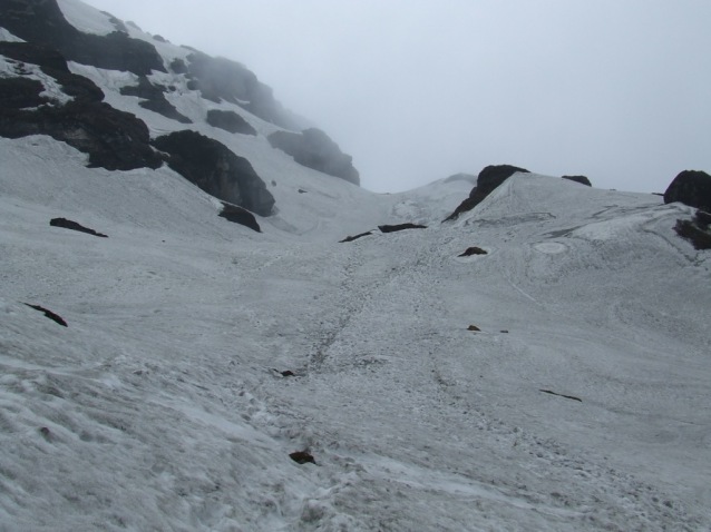
If there were only four passes (Kongma, …, Shipton, Keke) to arrive to Dobate with Shipton peaking at 4234m, the walk would be almost a formality. But the snow is always there with more than one meter in thickness in certain places. It spreads on the longest part of the route. The path remains often well indicated but endless sinking up to the thighs is exhausting.

The weather quickly becomes cloudy and the fog fills all the space. A short and unreal moment, peaks 6 and 7 appear. I get closer to the high mountains!

I meet three yaks coming down in the direction of Kongma. When it will be necessary to follow the same way, each of their steps forming a column of space in the snow down to the ground will be a trap still slowing down my progress.

DSCF1534

DSCF1538        DSCF1540

  DSCF1545

Icy snow walls must be crossed with the help of hands to reach the third pass. The path has disappeared under the snow and the trek is similar to climbing. I begin to understand the negative words of the park’s manager in Tashigaon.

The lake preceding Keke La is partially covered with snow and ice. Ice cracks under my foot and a shoe fills with water. I hurry to go out and to empty it but the damage is done.

The descent towards Dobate where the husband of the Kongma lodge’s owner waits for me, Pemba Sherpa, is more serene: the snow almost disappeared and the red and yellow rhododendrons alternate.

I shall spend a good evening there. His English allows us to exchange on his life and on my project. I have some difficulties understanding how he can live so isolated and far from his family. Apparently, this situation suits him very well. Many families are, like him, separated during the autumn and spring seasons between Tashigaon and the high valley pastures leading to MBC.

I dry my shoes and my pants close to the fire and drink tea without counting.

DSCF1556     DSCF1562

DSCF1564

Wednesday, 14 May – from Dobate to Yangle kharka

Descent -256m in 9.6km; altitude at night 3644m

Up at 6:05; 0°C in the room; departure at 7:20 arrived 14 15 in the rain.

DSCF1567 Dobaté Yangle Kharka 

The weather is beautiful in the early hours and mountains appear by stealth, for a little while … During the copious breakfast made of pancakes and tea, Pemba warns me that a rockslide destroyed a big part of the track leading to Yangle Kharka, the only hamlett opened before MBC and thus an inescapable stop. He prepares two additional pancakes for my lunch.

I find a waterfall shortly after Dobate and I take advantage of a ray of sun to take a great shower.

I change the first set of batteries for the GPS. The descent towards the Barun’s valley complicates and I believe to be in the collapses described by Pemba because I am sometimes in an almost vertical channel which has to be the bed of a torrent when it is raining. It is not the case and it is only a stimulating appetite walk compared with the long kilometer of unstable rocks that waits for me along the Barun!

At noon, the rain begins to fall. At first insignificant then expanding. After the forest, the grazing appears and the path becomes easier. I arrive to Yangle Kharka at the right time because the rain doubles intensity and I would not have stayed dry a very long time in these conditions.

DSCF1570    DSCF1573DSCF1574

Yangle Kharka seems very boorish for a hamlet at this low height. I am so far from Annapurna!

Sad and long afternoon to try to warm myself close to the wood fire where will be prepared my evening dalbath. This simple thought kills my appetite. Everything is dirty and nice here. The rain prevents any serene vision for an immediate future.

DSCF1578

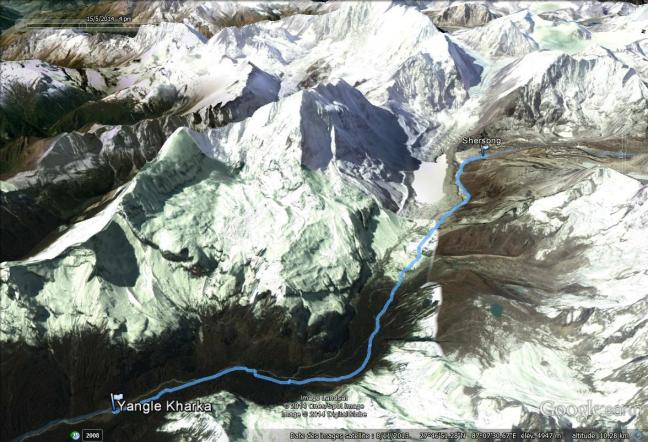
Thursday, 15 May – from Yangle Kharka to Shersong

Ascent  : 1071m in 12.91km; altitude at night:4715m

Up at 5:08 3°C inside  Departure:  6:10 arrived at 14:46

DSCF1586 Yangle Kharka Shersong         

Departure after a breakfast of pancakes and tea. I subscribe to pancakes because it seems a speciality of the region. I order it also for my lunch to save my reserves. And it is so famous after the perpetual dalbath …

The next accommodation is situated in MBC and requires a 1200m ascent. All the farms are closed between. There is a real risk of mountain sickness. We know how that begins with a big migraine and nausea. You never can tell how it will finish. Back in Khandbari, my friends will tell me that they were very worried because they had heard, from authorized source, that a French had died in MBC during his sleep. They thought that it was me …

Thanks to my equipment, I plan to stop to Shershong (with none shelter place). I shall not make there my second day of acclimatization as expected because it will be made at MBC at two hours and 200m ascent from there.

The valley must be magnificent when the weather is clear. It is not the case today. The sun remains hidden very often and thick layers of fog hang on to the trees of the valley and the abrupt hillsides of mountains. It’s a pity but, normally, the weather should improve with the height…

DSCF1587      DSCF1588

DSCF1593

In Yak Kharka as in Langmale, buildings are actually closed with padlocks. Refuge is possible however possible in adjacent shelter if necessary.

A silent kid follows me during dozens of minutes. I go nevertheless very slowly for him. He will be joined by his father and his brothers. They go  to the second base camp where, it seems, more than 200 people prepare expeditions to overcome the summit of Makalu. I imagine, in my long solitary walking, the kinds of traffic jams which have to reign there. I have never understood this paradox: so much personal effort to find themselves finally crowding in places so empty, mineral and majestic. Each to his cup of tea!!

DSCF1602

DSCF1606       DSCF1610

The air begins to be lacking and it is necessary to manage the beatings of my heart which is now beating too fast with the slightest effort. Stops are necessary more and more often. No matter, I have time.

I arrive under the snow to Shershong and I find a water source at 150m from the camp. I set up my tent  for the first time without any problem. The weather clears up in the afternoon, enough so that peaks 6 and 7 appear in an supernatural environment. These enormous cliffs, so close, set the tone of what will be my environment from now on.

My first autonomous evening in these conditions gets me a compensatory happiness for the past efforts and a strong motivation to continue towards the Barun’s glacier …

I have to erase a big migraine with some Ibuprofen and I have the impression that my heart is going to stop because it beats very slowly. These almost 1100m of ascent at this level are too important. The night will be difficult and long with numerous awakenings because of my difficulty to breth: I went up too fast.

DSCF1613     DSCF1618

DSCF1623

Friday, 16 May -From Shershong to the Base camp of Makalu    

 T internal 0°C; T outside-7°C Up at 5:10 Ascent 126m on 3.57 km

Departure 8:07 arrived 10:00; altitude at night 4841m 

DSCF1625 Shersong MBC

It is Sylvie’s birthday. I wish her Happy birthday by the thought.

At the exit of Shershong, I locate the crest which leads to the high pastures above MBC, described by Philippe in Kongma. If I do not manage to progress towards East Pass after MBC, I shall go up to discover the chain from Everest to Kanchenjunga …

I get ready quite slowly because the road will be short today.

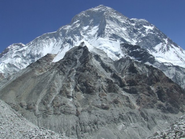
The weather clears on the road. It bodes well. For the first time, Makalu appears to me, majestic and wearing a curl of clouds. We shall not leave each other during 5 days.

DSCF1632

  DSCF1634


I take advantage of the sun to get washed a little less basically than usually. I also dry tent and sleeping bag, wet in Shershong.

I go in recognition of the path, following Barun’s glacier afternoon. It begins well drawn (stop at WP413). I cross in great shape my first 5000m during this exploration.

The lodge is very basic but the atmosphere is friendly. Carriers come to spend the night and we share our dinner there. It is -1°C at about 4 pm and I am afraid of lower temperatures higher, when I shall be alone.

DSCF1758DSCF1640

Saturday 17 May – From MBC to Sandy camp

Ascent: 359m on 5.16km; altitude at night: 5200m

Up: 5:08 Departure: 6:08 arrived: 12:20

DSCF1641 MBC Sandy Camp

I stop at 7:30 to protect me with sun cream: the sun is present and burns as soon as it gives to these heights. The weather will remain totally clear during my stay above MBC. This respite is a big chance which will allow me to benefit completely from extraordinary and always renewed spectacles.

DSCF1644

DSCF1658

I have to leave the path which leads to the second base camp because I have to go to the left to join Sandy Camp. This hypothetical camp is not situated on any map and was located on GE. When I leave the path, it becomes chaotic, on the back of the glacier.

DSCF1652

DSCF1656

I progress now in the unstable rocks and I join the line of break between the glacier and the hillside on the right bank of the glacier. It is not the best solution because it is a zone of fallen rocks where the progress is difficult and dangerous. I constantly think that a broken leg means the death now. Nothing very heartening. I recognize finally Sandy Camp’s location in an overhang of small hundred meters. I knew that climbing would not be simple there and I had planned to go up by forming zigzags on the slope. It is not so simple because rocks, from all sizes, fall down and slide by pulling others with them. Nothing holds. I choose to go up by the bed of a waterfall, thinking that stones will form a more coherent set, thanks to the flows of water. Nothing changes it. On the contrary, the simple fact of putting my foot somewhere diverts sometimes the current  towards me.

I am not proud when I get, dipped, to the top. The experience is not to renew!

There is so much collapse here as there was of avalanches in the valley surrounding Dhaulagiri. It is necessary to become used to these new songs of the mountain.

Accéder à Sandy Camp est un exercice délicat: éviter de déplacer de trop gros blocs de granit en progressant

Accéder à Sandy Camp est un exercice délicat: éviter de déplacer de trop gros blocs de granit en progressant

  DSCF1671

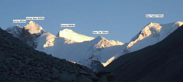
Sandy Camp is a magnificent terrace of fine and white sand, a real paradise for a sunbathing in an environment of snowy peaks, in the crystalline sound of the near torrent and in front of unchanging Makalu. Afternoon passes, enjoying the simple pleasure of the sweetness of the sun and the fantastic view on Lhotse (8516m),  Lhotse Shar (8393m), Everest at 18 km (8848m), Shar Tse (7591m), Shar Tse 2 (7457m) .

DSCF1678part

DSCF1673

My heart beats now too fast without making any effort. Everything will be back to normal in the evening and the migraine is not there.

It is 15°C in the tent in 17:00. My fear of low temperatures at high height was not founded.

DSCF1681

Sunday, 18 May – From Sandy Camp to the Camp of the Pass

Ascent: 273m in 3km;  altitude at night: 5473m

Up at 4:56 T=2°C inside, -5°C outside

Departure 6:55 arrived at 14:30

DSCF1677 Sandy Camp Camp du Col

DSCF1685

The setting-up time is now more important than in lodge because it is necessary to unsettle and to tidy up all the equipment and to prepare the breakfast (muesli + milk 100g and cappuccino with Brittany biscuits)

The weather is fair and I follow the road planned in my GPS It brings me up while staying on the flat which goes along the Barun’s Glacier. I saw dozens of times the profile of this mountain which I have the impression to know by heart. I find cairns sometimes. It really had to be a path a long time ago. The condition of the garbage at Sandy Camp reminds me that it was not used for several years.

The first part is made without too much difficulty. The descent towards the glacier and the moraine leading towards the East Pass is much less easy because the slope is too important for trying a direct descent. To try to join the glacier by staying on a horizontal is not more possible because the wall of the hillside becomes more and more vertical. I once fall, taken by the weight of the backpack. Arrived on the moraine, I continue to follow my GPS points but the ground is always so unstable.

After a fruitless attempt of progress towards the foot of the main glacier going downhill to East Pass, I decide to stop on a sandy location which  was a formerly camp, that I baptize Camp of the Pass, for lack of any better name. The location is ideal to plant the tent, always in front of Makalu, but higher and higher with regard to it.

vue sur l'amont du glacier avec le Cho Polu au fond, but ultime du trek Makalu 2015

vue sur l’amont du glacier avec le Cho Polu au fond, but ultime du trek Makalu 2015

Le Makalu, majestueux et définitivement dominateur

Le Makalu, majestueux et définitivement dominateur


DSCF1701

I saturate with meals of dry sausage and tasteless couscous. It will be necessary to vary the menus the next time. I dream about a tomato soup …

It is today one first record : my highest ground night, at 5473m … And everything goes well.

DSCF1703

DSCF1706      DSCF1708

DSCF1709

Monday 19 May – From the Camp of the Pass to the East pass’ Belvedere and return

final altitude 5850m;  ascent: 377m in 1.8km

Up at 5:08 Departure at about 8 am. Arrived at  10:00

T =-1°C inside T =-10°C outside

It is only when having unsettled and tidied up my things that my look is attracted by the slope which faces my camp in the direction of East pass. It seems to me obvious that from this height, I shall have a good point of view allowing me to decide on the way to be followed. I have a choice to be made: either come down towards the MBC to join the heights above Shersong, the antenna recommended by Philippe in Kongma, or go up towards East pass today if I find a more or less safe passage.

Half an hour has to be enough. I do not even take water.

DSCF1711       DSCF1712

un des glaciers du Makalu

un des glaciers du Makalu

Without bag, the ascent appears to me a soft escapade. A crest masks other one and it is necessary to go on climbing to hope to have a finally clear view. I need 2 hours to see finally appearing the mountains’ circus  surrounding East Pass. The glacier is enormous, inescapable and spotless. To cross it alone and without appropriate equipment seems to me totally irresponsible. The bell of return has just rung. I am at 5855m. A helicopter takes brutally me out of my dreams. It is the first contact in three days. It was on the way to the second base camp of Makalu when the pilot saw me in the middle of nowhere. He comes towards me and I make a sign meaning that everything goes well. Everything goes very well even because I taste the success of my project as a gourmet in the various small dishes in the delicious flavors.

DSCF1726pan

Sherpani pass, at the bottom to the left, appears to be a wall of unbridgeable ice. East pass, at the bottom to the right, seems more feasible after the long ascent of the glacier!

DSCF1730       DSCF1731

DSCF1734

What I do not still know is that I am just at the middle point between my camp and a summit rising in 6072m, easily accessible and from which Baruntse is completely visible. It will be for next time …

Down to the camp, I plant my tent on the same location … That misses a little of anticipation. We shall do better next time.

The weather covers little at the end of afternoon, enough to worry me a little bit.

Tuesday 20 May – Return to the Makalu Base camp

Descent: -632m in 7.28km, altitude at night 4841m

Up at 4:48,  T =-1°C inside-10°C outside. Departure 7:25. Arrived 17:45

I guzzle my fourth extraordinary breakfast. The road will be long and difficult today to join MBC.

There are two important difficulties to overcome because I do not want to try the low way by the meeting place of the side glacier where I am with that of Barun. I go back up on the plateau which leads to Sandy Camp without finding my way back on the way out. The GPS gives me a big service. I come down from the plateau towards the Barun’s glacier by preferring to slide on a glacis of bits of gravel and sand. Everything leaves with me but the advantage is to have the same speed which allows to plan and to avoid the biggest pebbles.

DSCF1745

This time, I prefer to avoid the masses of fallen rocks by progressing on an uncertain line on the back of the glacier in the direction of the path to the second camp of Makalu. I avoid so much as possible hollows and bumps formed over the centuries by the slow advance of the glacier.

DSCF1750      DSCF1752

Marcher sur le glacier, c'est poser les pieds sur des blocs de granit en équilibre instable

Marcher sur le glacier, c’est poser les pieds sur des blocs de granit en équilibre instable

  DSCF1755

My jeans will not take out whole there, torn in legs and on buttocks and my fingers of the left hand will superficially be cut, due to rubbing on granite rocks.

I arrive really exhausted but happy to see again human beings in MBC after more than 10 hours of walking. Excellent evening when I celebrate my victory with the local vodka.

Wednesday, 21 May – from MBC to Yangle kharka

Descent -1197m in 16.43km

Departure 7 :20 arrived 15 :15  Altitude at arrival: 3644m

At noon, the drizzle joined in. The return at the low heights is synonymic of overcast weather apparently. But nothing more can affect my morale now.

My times of walking are too long. The ideal is 7 hours for one day. But Sherpa make in one day what I travel in three. It’s difficult in these conditions to find coordinated places of stays. They go from MBC to Tashigaon in only two days …

I saw, this time, a shepherd installed in Shershong under a roof of covers recently settled. The farm of Langmale was also open and it would probably have been possible to take a meal or at least some tea there.

I meet my only group of carriers of the day. Seen their drunkenness, I do not have to be any more far from Yangle Kharka …

DSCF1759      DSCF1763

DSCF1765

It is not either by going down it that I was able to admire this magnificent valley. I spend an excellent evening with my new friends. Here the words are not necessary to feel integrated into the family by sharing the meal together. Some words as lasso (thank you) or salti (ni) (friend) cause true laughting and the conviviality is very there.

Thursday, 22 May – from Yangle Kharka to Dobate            

Ascent: 256m in 9.9 km; Alttude at night: 3900m

Up at 5:45 departure 7:20 arrived 15:00

The weather is as yesterday and on the way out covered. The ascent towards Dobate is terrible even with my bag having lost more than 2 kilos.

DSCF1773      DSCF1782

DSCF1787

The evening with Pemba and carriers will be a big reward of the efforts of the day. I discover the traditional sucutti, the yak meat dried by fire and placed again in the flame to be tenderized. Taste and share without moderation with the local Arack. The social life, in its original sense about which I am fond of is there. It is like a fabric warped day after day by the tradition. Everybody takes a place here in the warmth after the efforts of the day. Extraordinarily, I am included in this precious fabric. We don’t to think about anything, we enjoy simply the present moment, together.

DSCF1793 DSCF1795


Friday, 23 May – from Dobate to Kongma

Descent -271m on 8.73km altitude at night: 3629m

Up at 5:35; departure 7:12 – Arrived 14 :45

Depature after review of my « exploit » by looking at photos with Pemba. He remember me that he had told, on the way out, by analyzing the drawings of cooking on my pancakes that my trek would be a success. His grandfather taught to him to read the future in this way.

It is the day of four passes. Everybody told me that the snow melted since my first passage. It is true that the path is a little more visible. It will be necessary to fight all the same step by step to move forward in the soft and thick snow on several kilometers, in the drizzle and the fog sometimes.

I look for the crampon lost on the way out without finding it.

DSCF1801       DSCF1804

DSCF1814

I find the warm atmosphere of Kongma where I shall spend a new exceptional evening. A dinner guest shows me his invaluable booty: he has in his pocket three yarsagumba, collected in the region of Yangle Kharka. It is about caterpillars infected by a mushroom which eventually kills them. Middle plants middle insect, this is a medicine with numerous virtues in particular the increase of the sexual capacities, that the rich Chineses buy at a high price, up to 5000€ / kg.

DSCF1820

Saturday 24 May – from Kongma to Tashigaon              

Descent: -1429m on 5.7km; altitude at night: 2200m

Up at 5:15 departure 7:30 arrived 13:30

I leave shaved but always dirty. I shall wait to find a waterfall to take a shower on the way while the temperature appreciably went back up.

In Tashigaon, the guesthouse is unfortunately closed because its owner left with helicopter to Kathmandu. I am disappointed and I go to the guesthouse where we stayed in March, 2013. The atmosphere is more hoisted and the exchanges more limited although cordials.

DSCF1838        DSCF1836

DSCF1844

Sunday, 25 May – From Tashigaon to Seduwa   

Descent:  -628 in 8.7km; altitude at night: 1572m

I find no more leeches on the way. I find Dawa in his school in Chyaksa danda where he took the place of Head teacher during my trek. It is an excellent news which we shall celebrate in family that evening by getting away the neck of one of its chickens in Seduwa.

DSCF1879       DSCF1875

  DSCF1882

DSCF1873


Monday 26 May – from Seduwa to Num

Descent:-49m in 4.8km, altitude at arrival: 1523m

Up: 6:55; Departure 7:45 arrived: :12:30

We shall never enough say that this abyss to be crossed between Seduwa and Num is a torture because we already believe that trial is finished when it is necessary to go up by an steeply ascent furthermore of 700m, in the tropical torpor.

DSCF1904

I arrive while a jeep goes away for Khandbari … It will be necessary to wait patiently that an other one fills, during three long hours. I would have preferred to spend this time in the company of my friends in Khandbari. We have so many things to be said ourselves …

DSCF1959pan4

DSCF1975        DSCF1968DSCF1986

 Annex GPS points

you can find the complete Excel spreadsheet on tab GPS/Tableurs – Spreadsheets

gps blog p1 gps blog p2

DSCF1678


De Num au Belvédère d’East Pass

Du 7 au 26 Mai 2014

DSCF1634


Cliquez sur les photos pour les agrandir – points GPS en annexe de l’article. 

Objectifs :

Après l’arrêt forcé à Kongma en avril 2013, du fait des chutes de neige tardives ayant bloqué l’accès à la Shipton la, j’organise une nouvelle virée vers le Makalu, 5ème sommet du monde trônant à 8434m.

L’objectif initial est de le contourner jusqu’à la « East Pass » 6150m, point final du projet, pour l’avoir bien en face, juste 2300m en dessous.

En marge de la rencontre de nos amis de Khandbari, Seduwa et Chyaksa danda, il s’agit d’une ballade en 17 jours sur un dénivelé total de 5400m, sur une distance de 130km aller retour


Résumé et Introduction:

Les vallées et crêtes menant aux monstres de hautes montagnes du massif du Makalu ne démentent pas leur réputation : le ciel sera fort encombré jusqu’au Camp de Base du Makalu (MBC). La pluie sera de la partie parfois dés la fin de matinée. En montant, le temps s’éclaircit pour laisser place à un ciel parfaitement limpide pendant mes quatre jours et trois nuits d’isolement après MBC. Ce répit  inespéré m’est laissé pour me fondre dans un univers fabuleux, qui marquera  mes rêves autant que mes tibias : la virée est dangereuse sur une grande partie du parcours, sans chemin, dans les éboulis de roches de parfois plusieurs centaines de kilos en équilibre instable.

Je n’irai pas jusque East Pass, objectif ultime de ce trek car l’énorme et incontournable glacier le précédant ne porte aucune trace de passage. Les risques sont trop grands. Je la contemplerai de mon belvédère improvisé et point culminant à 5850m, joli lot de consolation…

Avec trois marcheurs étrangers croisés en trois semaines, on peut dire que le parcours est confidentiel. Cette région Sherpa vaudrait pourtant d’être mieux connue, tellement chaleureuse qu’il n’est pas besoin de savoir parler leur langue pour échanger et passer des soirées longues et inoubliables en partageant sans modération rocksi (arak en Sherpa : alcool de millet distillé une fois), sucuti (viande de yak séchée recuite au feu de bois) et l’immuable dalbath.

Il est précieux de découvrir leur culture mélée de jovialité, de candeur et de franchise.  En espérant qu’elle reste longtemps accrochée  aux versants sublimes de leurs montagnes sacrées.


Préparation :

Le trajet et les étapes sont positionnés à l’aide de Google Earth (GE) et les points entrés dans le GPS Garmin.

5  Jours d’autonomie sont prévus (2.6kg de nourriture + tente).

Le poids total emporté s’élève à 18kg, inclus, l’eau, l’essence et le sac photo. Sacs à dos : Gregory Wander 70 ; Tente : Vaudé Power Lizard SUL 2 places ; Réchaud :  MSR XGK EX avec 400ml (100ml  suffiront) d’essence achetée à une station service de Kathmandu ; matelas: Thermarest Néoair XLIT

Sacs de couchage: Valandré Bloody Mary

Voyage accompagné de mes amis de Friends of Nature jusque Tashigaon puis solitaire jusqu’au belvédère d’East Pass.


Situation et parcours:

DSCF1373 situation


DSCF1373 trajet

Accés :

Turkish Airlines, « meilleure compagnie européenne »,  ne démentira pas sa récente réputation. Très bon voyage pour 584€, c’est l’accés le plus direct à KTM. Pourvu que ça dure… Les billets KTM Tumlingtar ont été achetés par internet, c’est une nouveauté appréciable. De Tumlingtar à Num, les jeeps partent lorsqu’elles sont pleines (14 passagers : 150Rs jusque Khandbari (une petite heure) puis 600Rs jusque Num (4-5 heures)

Une route est en construction pour continuer, dit-on jusque Tashigaon (pas trop vite !)


Budget :

Vols international : 584€ , vol KTM Tumlingtar : 184€, visa, droit d’entrée dans le parc, hébergements et repas KTM et trek : 420€, soit au total moins de 1200€


Agenda :

agenda

Altitude à l’étape :

Altitude à l'étape

altitude distance

dénivelé jour

Le trek au jour le jour

Mercredi 07-mai de Num à Seduwa

Dénivelé 49m     6km en 4 h30 ; altitude le soir 1572m

DSCF1406a Num Seduwa


Après 3 heures d’attente, nous préférons payer la dernière place qui restait désespérément vide pour pouvoir enfin partir. 4 heures de jeep enfin entre Khandbari et Num sur une piste chaotique ouverte il y a cinq ans. Nous avons de la chance cette fois-ci car la pluie ne tombe pas.
DSCF1406DSCF1406b


La marche ne commence que vers 13heures après l’incontournable dalbath à Num, sensé donner des forces pour le parcours. Il faut s’habituer au sac, bien lourd, qui me déséquilibre à chaque faux pas.

La descente de Num est vertigineuse. Elle évite une véritable falaise qui tombe dans le lit du Barun.

J’ai beaucoup de mal à suivre Sanjaya, habitué au chemin. Nous arrivons peu avant la tombée de la nuit à Seduwa. Nos amis nous y attendent et les retrouvailles se fêteront à la Tomba locale (bière de millet qui continue de fermenter avec les ajouts successifs d’eau chaude dans le mélange. Une tourista se dessine en perspective. C’est malheureusement une bonne idée d’éviter la tomba et le tchang sauf si l’eau servant aux breuvages a suffisamment bouilli ou a été traitée préalablement.


Jeudi 08- et  vendredi 09-mai. Interruption du trek. Séjour à la Ferme de Friends Of Nature entre Chyaksa Tashigaon


C’est une occasion idéale pour entrer dans les maisons Sherpa et partager leur vie quotidienne. Mes amis traduisent mais pas besoin de mots pour apprécier le tchang préparé par la maîtresse de maison devant nous. Le principe est de ne pas laisser les verres se vider. Il faut qu’ils soient toujours pleins. Nous assistons aussi à la distillation de ce breuvage qui prendra le nom de Rocksi au Arack ou encore Local. La source froide se situe dans la marmite supérieure et doit être changée régulièrement pour permettre la condensation du distillat.

A l’inverse du tchang et de la tomba, cette boisson est tout à fait sûre pour le système digestif. A consommer cependant avec modération.

A la ferme de Friends of Nature, nous tuerons aussi le poulet qui améliorera considérablement  le dalbath. Sur ces terres, l’expérimentation de la culture du kiwi a débuté au printemps. Ce sera bientôt une source de vitamines pour toutes les populations de la vallée (environ 4000 personnes)

DSCF1410DSCF1446DSCF1447

samedi 10-mai  jusqu’à Tashigaon, 

DSCF1407 Seduwa Tashigaon

Dénivelé 628m en 8.45km à partir de Seduwa. altitude le soir :2200m

Nous continuons à marcher dans les rizières et je découvre mes premières sangsues. Elles s’accrochent aux semelles ou aux vêtements lorsqu’on les frôle. Elles s’infiltrent ensuite sous les vêtements pour boire le sang en toute tranquillité. Elles sont nombreuses entre Seduwa et Tashigaon mais je n’en verrai plus par la suite. Pour les éviter, il faut marcher au maximum sur les pierres et éviter les bords des chemins.

La campagne reste paisible et chaude. Le temps couvert ne permet pas de distinguer les montagnes environnantes.

A Tashigaon, nous fêtons mon départ en solo le lendemain avec force bières. Le manager du parc me met en garde sur les difficultés du parcours et me fait comprendre qu’il peut être sage de ne pas aller jusqu’au Camp de Base. J’en prends acte sagement mais je brûle d’impatience de me coltiner enfin aux vraies difficultés du parcours. Il sera moins sage que moi en s’enfilant 14 bières de 66cl dans la soirée.

DSCF1487

DSCF1470

Dimanche 11-mai : de Tashigaon à Kongma      

DSCF1495 Tashigaon Kongma


Dénivelé : 1429m en 6.45km, altitude à l’arrivée : 3629m

Lever à 5 :20, départ à 6 :20. Arrivée à 13 :45

La montée de Tashigaon à Kongma est pratiquement continue dans la forêt. Je profite de cette dernière journée en ambiance tropicale. Les oiseaux se répondent à l’infini. Les derniers rhododendrons illuminent d’éclats rouges le chemin. La montée est un obstacle. Il ne faut pas chercher à aller plus vite que de raison. L’air ne manque pas encore mais le chemin se dilue déjà en volées d’escaliers disjoints sur lesquels les pieds cherchent encore, maladroits, un appui souvent incertain. La montée est longue. Il faut être patient. C’est le prix à payer pour échapper, peut-être, à la brume qui entoure toute chose dés que le soleil commence à donner.

Il y a peu d’habitations sur le chemin, quelques fermes dont une permet le ravitaillement et même un déjeuner lorsqu’elle est ouverte WP342.

Un sherpa que je croise dégage une haleine fortement alcoolisée. J’apprendrai par la suite qu’ils y trouvent l’énergie pour porter leurs lourdes charges avec moindre peine.

Je retrouve Kongma sans l’écrin de neige que nous avions laissé, il y a un peu plus d’un an. Les murs presque verticaux que je franchis aujourd’hui étaient alors couverts de neige. Je suis plus à l’aise.

DSCF1497DSCF1509DSCF1511DSCF1518 


Lundi 12-mai      à Kongma, journée d’acclimatation

J’hésite à rester mais je veux être raisonnable. Le beau temps m’invite pourtant à partir. J’ai rencontré la veille mon premier trekkeur. Il redescend du Makalu et m’indique une belle antenne à partir de Shersong : une arrête à prendre en restant sur la gauche pour surplomber le camp de base à 5300m voire plus en direction du peak 3 . En s’installant là haut on peut découvrir simultanément le Makalu, l’Everest, le Lhotse et le Kanchenjunga par temps clair.  Je n’irais pas cette fois-ci si je peux aller vers l’East Pass qui reste mon projet.

La journée est longue à Kongma. J’en profite pour faire ma première lessive et une toilette un peu moins superficielle. Il faut reconnaître que ce n’est pas facile de rester un peu propre sur ce parcours. A partir de Tashigaon, il n’existe pas de point d’eau un peu isolé sauf les éventuels WC…

Je commande des chapatis pour le petit déjeuner. Mauvaise idée car la propriétaire comprend chiapati. Elle commence à me préparer du thé tibétain. Je ne confondrai plus « chiapati » thé tibétain et « tchapati ». D’ailleurs tout le monde sait faire des pancakes, ici, bien plus nourrissants…

DSCF1524

Mardi 13-mai    De Kongma à Dobaté

DSCF1525 Kongma Dobaté


dénivelé: 290m en 7.53km     altitude à l’arrivée :3900m

Lever à 5 :30, 4°C dans la chambre. Départ à 6 :40 Arrivée à 14 :00. WP405

S’il n’y avait que les quatre cols (Kongma, …, Shipton, Keke) pour arriver à Dobaté avec le Shipton la culminant à 4234m, l’épreuve serait  presque une formalité. Mais la neige est toujours au rendez-vous avec plus d’un mètre d’épaisseur à certains endroits. Elle se répand sur la plus grande partie du parcours. Le chemin reste souvent bien indiqué mais s’enfoncer jusqu’aux cuisses sans fin est épuisant.

Le temps se couvre rapidement et le brouillard remplit tout l’espace. Un court instant, irréel, les peaks 6 et 7 se découvrent . Je me rapproche de la haute montagne !

Je croise trois yacks seuls redescendant en direction de Kongma. Lorsqu’il faudra suivre leur chemin, chacune de leurs traces formant une colonne de vide dans la neige jusqu’au sol seront autant de  pièges ralentissant encore ma progression.

DSCF1534  DSCF1538

DSCF1540  DSCF1545

De vrais murs aux parois glacées doivent être franchis, parfois avec l’aide des mains pour atteindre le troisième col. Le chemin a disparu sous la neige et le trek s’apparente à de l’escalade. Je comprends mieux les paroles peu engageantes du directeur du parc à Tashigaon.

Le lac précédant la Keke la est partiellement recouvert de neige et de glace. Je dois le frôler de trop prés car j’y enfonce mon pied. La chaussure gauche se remplit d’eau. Je me dépêche de la défaire pour la vider mais le mal est fait.

La descente vers Dobate où m’attend le mari de la propriétaire du lodge de Kongma, Pemba Sherpa, est plus sereine : la neige a presque disparu et les rhododendrons rouges et jaunes alternent joyeusement.

J’y passerai une bonne soirée. Son anglais nous permet d’échanger sur sa vie et sur mon projet. J’ai du mal à comprendre qu’il puisse vivre aussi isolé et loin de sa famille. Visiblement, sa situation lui convient très bien. Beaucoup de familles sont ainsi séparées pendant les saisons de printemps et d’automne entre Tashigaon et la vallée de hauts alpages conduisant à MBC.

DSCF1556  DSCF1562DSCF1564

Je sèche mes chaussures et mon pantalon au plus prés du feu en buvant du thé sans compter.


Mercredi 14-mai de Dobaté à Yangle kharka

 DSCF1567 Dobaté Yangle Kharka           

dénivelé -256m en 9.6km   Altitude à l’arrivée 3644m

Lever à 6 :05 0°C dans la chambre ; départ à 7:20 arrivée 14 :15 sous la pluie.

Il fait beau au petit matin et les montagnes se découvrent un peu, pour peu de temps… Pendant le petit déjeuner copieux composé de pancakes et de thé, Pemba me prévient que des éboulements ont emporté une partie de la piste qui mène à Yangle Kharka, seul lieu ouvert avant MBC et donc arrêt obligé.  Il me prépare deux pancakes supplémentaires qui composeront mon repas de midi.

Je trouve une chute d’eau peu après Dobaté et je profite d’un rayon de soleil bienfaiteur pour faire une toilette complète.

Je change mon premier jeu de pile pour le GPS.

La descente vers la vallée du Barun se complique et je crois me trouver dans les éboulements décrits par Pemba car j’empreinte un canal parfois presque vertical qui doit être le lit d’un torrent quand il pleut.  Il n’en est rien et ce n’est qu’une promenade apéritive comparée au bon kilomètre de roches instables qui m’attend le long du Barun.

A partir de midi, la pluie commence à tomber., d’abord insignifiante puis prenant de l’ampleur. Après la forêt, les pâtures apparaissent et le chemin devient plus praticable. J’arrive à Yangle Kharka au bon moment car la pluie redouble d’intensité et je ne serais pas resté au sec bien longtemps dans ces conditions.

DSCF1570  DSCF1573DSCF1574

Yangle Kharka me paraît bien rustre pour un hameau à basse altitude. Je suis tellement loin des Annapurna !

Triste et long après midi à tenter de me réchauffer prés du feu où sera préparé mon dalbath du soir. Cette simple pensée me coupe l’appétit. Tout est sale et sympathique ici mais la pluie empêche toute vision sereine de l’avenir immédiat.

DSCF1578


Jeudi 15-mai     de Yangle Kharka à Shersong

DSCF1586 Yangle Kharka Shersong         

dénivelé : 1071m  en 12.91km   Altitude à l’arrivée :4715m

Lever 5 :08 3°C dans la chambre

Départ 6 :10 arrivée 14 :46

Départ après un petit déjeuner de pancakes et thé. Je m’abonne aux pancakes car c’est une spécialité de la région apparemment. J’en commande pour mon repas de midi pour économiser mes provisions. Et c’est tellement fameux après les sempiternels dalbaths…

Le prochain hébergement se situe à MBC et nécessite un dénivelé de 1200m. Tous les autres lodges sont fermés entre deux. Il y a un risque réel de mal des montagnes. On sait comment ça commence avec une bonne migraine et des nausées. On ne sait jamais comment ça finit. A ma descente, mes amis me diront qu’ils étaient très inquiet car ils avaient entendu, de source sûre, qu’un français était décédé à MBC pendant son sommeil. Ils pensaient que c’était moi…

Grâce à mon équipement, je prévois de m’arrêter à Shershong (aucun abris couvert). Je n’y ferai pas ma seconde journée d’acclimatation comme prévu car elle sera faite à MBC à deux heures  et 200m de dénivelé de là.

La vallée doit être superbe quand le temps est dégagé. Ce n’est pas le cas aujourd’hui. Le soleil reste caché très souvent et d’épaisses couches de brouillard s’accrochent aux arbres de la vallée et des versants abrupts des montagnes. Dommage. Normalement, le temps devrait s’améliorer avec l’altitude.

DSCF1585  DSCF1581

DSCF1587  DSCF1588

DSCF1593

A Yak Kharka comme à Langmale, les bâtisses sont effectivement fermées au cadenas. Il est possible cependant possible de s’y réfugier dans un abris couvert attenant en cas de besoin.

Un gamin silencieux me suit pendant plusieurs dizaines de minutes. Je vais pourtant très lentement pour lui. Il sera rejoint par son père, porteur, et ses frères. Ils se rendent au camp de base avancé où, paraît-il, plus de 200 personnes préparent des expéditions pour vaincre le sommet du Makalu. Pauvre Makalu! J’imagine, dans ma longue marche solitaire, les genres d’embouteillages qui doivent y régner. Je n’ai jamais compris ce paradoxe : tant d’effort personnel pour se retrouver finalement en totale promiscuité dans des lieux aussi vides, minéraux et majestueux. A chacun sa tasse de thé !

DSCF1602   DSCF1606

DSCF1610

L’air commence à manquer et il me faut gérer les battements du cœur qui s’emballe maintenant au moindre effort. Les arrêts se font de plus en plus rapprochés. Peu importe car j’ai du temps.

J’arrive sous la neige à Shershong et je trouve un point d’eau à 150m du camp. Je monte pour la première fois et sans problème la tente. Le temps s’éclaircit dans l’après-midi, assez pour que les peaks  6 et 7 se découvrent dans un environnement d’autant plus surnaturel qu’inattendu. Ces énormes falaises, si proches, donnent le ton de ce que sera mon environnement dorénavant.

Ma première soirée autonome dans ces conditions me procure un bonheur compensateur des efforts passés et une forte motivation pour continuer vers le glacier du Barun…

J’ai quand même du faire passer une grosse migraine avec de l’ibuprofène et j’ai l’impression que mon cœur va s’arrêter tant il bat lentement. Ces presque 1100m de dénivelé à cette altitude sont trop importants. La nuit sera difficile  et longue  avec de nombreux réveils à cause de ma difficulté à respirer : je suis monté trop vite.

DSCF1613  DSCF1618

DSCF1623


Vendredi 16-mai             de Shershong au Camp de Base du Makalu       

DSCF1625 Shersong MBC

Dénivelé 126m en 3.57km

T intérieure 0°C ; T extérieure -7°C

Lever 5 :10

Départ 8 :07 arrivée 10 :00

altitude à l’arrivée 4841m WP412

C’est l’anniversaire de Sylvie qui me manque.Je lui souhaite un Bon Anniversaire par la pensée.

Je repère,  à  la sortie de Shershong, l’arrête qui conduit aux hauts pâturages au dessus de MBC, décrite par Philippe à Kongma. Si je n’arrive pas à progresser vers l’East Pass après MBC, je monterai pour y découvrir toute la chaîne de l’Everest au Kanchenjunga…

Je me prépare doucement car la route sera courte aujourd’hui.

Le temps se découvre un peu sur la route . C’est de bon augure. Pour la première fois le Makalu, majestueux et panaché d’une volute de nuages, se présente à moi. On ne se quittera plus pendant 5 jours.

DSCF1632  DSCF1634DSCF1636

Je profite du soleil bienfaiteur pour faire une toilette un peu moins sommaire que d’habitude et une lessive sous l’œil attentif de Pasang, la propriétaire de mon lodge. Je sèche aussi tente et duvet humides après la nuit à Shershong.

Je pars en reconnaissance du chemin longeant le Barun dans l’après midi. Il est exceptionnellement bien tracé dans les kilomètres que je parcours (point final WP413). Je franchis en pleine forme mes premiers 5000m au cours de cette exploration.

Le lodge est fort sommaire mais l’ambiance y est amicale.. Des porteurs viennent y passer la nuit et nous y partageons notre diner. Il y a fait déjà -1°C vers 16 heures et je m’inquiète un peu des températures à supporter plus haut, quand je serai seul.

DSCF1758DSCF1640


samedi 17-mai  de MBC à  Sandy camp  

DSCF1641 MBC Sandy Camp

dénivelé 359m  5.16km ; altitude à l’arrivée : 5200m

Levé 5 :08

Départ 6 :08 arrivée 12 :20

Je m’arrête à 7 :30 pour me protéger avec de la crème solaire : le soleil est de la partie et brûle dés qu’il donne à ces altitudes. Le temps restera totalement clair pendant mon séjour au dessus de MBC. Ce répit est une grande chance qui me permettra de bénéficier pleinement des spectacles extraordinaires et toujours renouvelés.

DSCF1644

DSCF1649pan1


DSCF1658

Il faut que je quitte le chemin qui mène au second camp de base car je dois me diriger vers la gauche pour rejoindre Sandy Camp. Ce camp hypothétique ne se situe sur aucune carte et a été repéré sur GE. Je quitte le chemin principal quand il oblique vers la droite et devient de plus en plus chaotique, sur le dos du glacier (WP416).

DSCF1652  DSCF1654

DSCF1656

Je progresse maintenant dans les rochers instables et je rejoins la ligne de rupture entre le glacier et le versant de la rive droite du glacier. Ce n’est pas la meilleure solution car c’est une zone d’éboulis où la progression est difficile et dangereuse. Je pense continuellement qu’une jambe cassée signifie la mort maintenant. Rien de bien réjouissant. Je reconnais enfin l’emplacement de Sandy Camp en surplomb d’une petite centaine de mètres. Je savais qu’y monter ne serait pas simple et j’avais prévu d’accéder à cette sorte de plate forme en formant des zig-zags sur la pente. Ce n’est pas aussi simple car les rochers, quelques soient leurs tailles se décrochent et glissent en entraînant d’autres avec eux. Rien ne tient. Je choisis de me hisser par le lit d’une cascade en pensant que les pierres formeront un ensemble plus cohérent  grâce à l’écoulement de l’eau. Rien n’y change. Au contraire, le simple fait de poser mon pied sur une pierre dévie parfois le courant vers moi.

Je ne suis pas fier lorsque j’arrive, trempé au faîte de la cascade. L’expérience n’est pas à renouveler !

Il y a autant d’éboulements ici qu’il y a d’avalanches dans la vallée encerclant le Dhaulagiri. Il faut s’habituer à ces nouveaux chants de la montagne.

DSCF1669  DSCF1671

Sandy Camp est une superbe terrasse de sable fin et blanc, un vrai paradis pour un bain de soleil dans un environnement de pics enneigés, au son cristallin du torrent qui s’écoule à côté et face à l’immuable Makalu. L’après midi s’écoule ainsi à jouir de la douceur apparente  du soleil et de la vue imprenable sur le Lhotse (8516m), le Lhotse Shar (8393m), l’Everest à 18 km (8848m), le Shar Tse (7591m), le Sha Tse 2 (7457m) 

DSCF1678partDSCF1673


Mon cœur bat maintenant trop vite sans effectuer aucun effort. Tout rentrera dans l’ordre dans la soirée et  la migraine n’est pas au rendez-vous.

Il fait 15°C dans la tente à 17heures. Ma hantise des basses températures à haute altitude n’était pas fondée.

DSCF1681

Dimanche 18-mai           De Sandy Camp au Camp du Col 


DSCF1677 Sandy Camp Camp du Col

Dénivelé 273m  pour     2.99km  Altitude à l’arrivée : 5473m

Lever à  4 :56

T=2°C intérieur -5°C extérieur

Départ 6 :55; arrivée à 14 :30

DSCF1685

Le temps de préparation est maintenant bien plus important qu’en lodge car il me faut démonter et ranger tout l’équipement et préparer le petit déjeuner (muesli + lait 100g et cappuccino avec palets bretons

Le temps est au beau fixe et j’emprunte la route prévue dans mon GPS en m’élevant tout en restant sur la plate forme qui longe le Glacier du Barun.  J’ai vu des dizaines de fois le profil de cette montagne que j’ai l’impression de connaître par cœur. Je retrouve des cairns parfois. Il doit réellement s’agir d’un chemin emprunté autrefois. L’état ancien des détritus du Sandy Camp (boîtes de conserve vides) me fait penser qu’il n’a pas été utilisé depuis plusieurs années.

La première partie se fait sans trop de difficulté. La descente vers le glacier et la moraine des glaciers conduisant vers l’East pass est beaucoup moins aisée car la pente est trop importante pour tenter une descente directe. Essayer de rejoindre le glacier en restant sur une ligne à peu prés horizontale n’est pas davantage possible car la paroi du versant devient de plus en plus verticale. Je tombe une fois, emporté par le poids du sac à dos. Arrivé sur la moraine, je continue à suivre mes points GPS mais le sol est toujours aussi instable.

Après une tentative infructueuse de progression vers le pied du glacier dévalant d’East Pass, Je décide de m’arrêter sur un emplacement sableux qui fut un campement, autrefois, et que je baptise Camp du Col, faute de mieux. L’emplacement est idéal pour planter la tente, toujours face au Makalu, mais de plus en plus haut par rapport à lui.

DSCF1697   DSCF1698

DSCF1701

Je sature des repas au saucisson et au couscous sans saveur. Il faudra varier les menus la prochaine fois.  Je rêve d’une soupe à la tomate…

C’est quand même le record de ma nuit terrestre la plus haute, à 5473m… Et tout va bien.

DSCF1703

DSCF1706   DSCF1708


DSCF1709

lundi     19-mai  du Camp du Col au Belvédère d’East pass


altitude finale 5850m

dénivelé 377m en 1.8km

Levé 5 :08

Départ vers 8 heures. Arrivée à 10 :00

T=-1°C intérieur

T= -10°C extérieur

Ce n’est qu’après avoir démonté et rangé mon barda que mon regard est attiré par la pente qui fait face à mon campement dans la direction d’East pass. Il me semble évident que de cette hauteur, j’aurai un bon point de vue me permettant de décider de la voie à suivre. J’ai un choix à faire : soit redescendre vers le MBC pour rejoindre les hauteurs au dessus de Shersong, antenne conseillée par Philippe à Kongma, soit pousser aujourd’hui vers East pass  si je trouve un passage à peu près sûr.

Une demi-heure doit suffire. Je ne prends même pas d’eau.

DSCF1711   DSCF1712

DSCF1714

Sans sac, la montée me paraît une douce escapade. Une crête en cache une autre qu’il faut grimper pour espérer avoir une vue enfin dégagée.  Il me faut 2 heures pour voir enfin apparaître le cirque de montagnes encadrant East pass. Le glacier est énorme, incontournable et immaculé. Le franchir seul et sans équipement approprié me paraît totalement irréaliste.  La cloche du retour vient de sonner. Je suis à 5855m. Un hélicoptère me sort brutalement de mes contemplations. C’est le premier contact depuis trois jours. Il se rendait au camp de base avancé du Makalu lorsqu’il m’a vu au milieu de nulle part. Il vient vers moi et je lui fait signe que tout va bien. Tout va très bien même car je goûte au succès de mon entreprise comme un gourmet aux différents petits plats aux saveurs exquises.

DSCF1726pan

Sherpani pass, au fond à gauche, paraît être un mur de glace infranchissable. East pass, au fond à droite, paraît plus praticable…après la longue remontée du glacier!

DSCF1730  DSCF1731

DSCF1734

Ce que je ne sais pas encore, c’est que je suis juste à mi distance entre mon camp et un sommet s’élevant  à 6072m, facilement accessible et à partir duquel le Baruntse est pleinement visible. Très dommage. Ce sera pour une prochaine fois…

Je replante ma tente sur le même emplacement… Ca manque un peu d’anticipation. On fera mieux aussi la prochaine fois.

Le temps se couvre un peu en fin d’après midi, suffisamment pour m’inquiéter un peu.

mardi    20-mai  Retour au Camp de Base du Makalu

dénivelé :-632m en 7.28km        Altitude à l’arrivée 4841m

lever 4 :48

T=-1°C intérieur -10°C extérieur.

Je m’enfile mon quatrième petit déjeuner extraordinaire. La route sera longue et difficile aujourd’hui pour rejoindre MBC.

Départ 7 :25. Arrivée 17 :45

Il y a deux difficultés importantes à surmonter car je ne veux pas essayer la voie basse par le point de rencontre du glacier latéral où je me trouve avec celui du Barun. A la réflexion, c’est pourtant peut-être la meilleure voie. Je remonte donc sur le plateau qui conduit à Sandy Camp sans retrouver exactement mon chemin de l’aller. Le GPS me rend un fier service. La marche sur le plateau est par contre beaucoup plus aisée. Je descends du plateau vers le glacier du Barun en préférant  glisser sur un glacis de gravillons et de sable. Tout part avec moi mais l’avantage est d’avoir une vitesse à peu prés égale à celle de tout ce qui dévale. Cela permet de prévoir et d’éviter les plus gros cailloux.

DSCF1742pan3

DSCF1745

Je préfère cette fois éviter les éboulis de l’aller en progressant sur une ligne incertaine sur le dos du glacier en direction  du chemin du camp avancé du Makalu. J’évite, autant que je peux, les creux et les bosses formés au cours des siècles par la lente avancée du glacier.

DSCF1750  DSCF1752

DSCF1751  DSCF1755

Mon jean ne s’en sortira pas entier, déchiré aux jambes et aux fesses. Les doigts de ma main gauche seront superficiellement coupés à force de frotter sur les rochers de granit.

J’arrive vraiment épuisé mais heureux de revoir des humains à MBC après plus de 10 heures de marche. Excellente soirée où je fête ma victoire à la vodka locale.


Mercredi 21-mai de MBC à Yangle kharka         

Dénivelé -1197m  en 16.43km

Altitude à l’arrivée : 3644m

Départ 7 :20 arrivée 15 :15.

A midi, la bruine s’est mise de la partie. Le retour aux basses altitudes est synonyme de temps couvert apparemment. Mais rien ne pourra plus entamer mon moral.

Mes étapes sont trop longues. L’idéal est bien de marcher 7 heures dans la journée. Mais les Sherpa font en une journée ce que je parcours en trois. Difficile dans ces conditions de trouver des lieux d’étapes coordonnés. Ils vont de MBC à Tashigaon en deux seules journées…

J’ai quand même vu un berger installé à Shershong sous un toit de bâches récemment installé. La ferme de Langmale était aussi ouverte et il aurait probablement été possible d’y prendre un repas ou au moins du thé.

Je croise mon seul groupe de porteurs de la journée. Vu leur état d’ébriété, je ne dois plus être loin de Yangle Kharka…

DSCF1759  DSCF1763

DSCF1765

Ce n’est pas non plus en la descendant que j’ai pu admirer cette magnifique vallée.  Je passe une excellente soirée avec mes nouveaux amis. Ici les mots ne sont pas nécessaires pour se sentir intégré dans la famille en partageant le repas ensemble. Quelques mots comme lasso (merci)  ou salti (ami) provoquent des rires francs et la convivialité est bien là.


Jeudi 22-mai de Yangle Kharka à Dobaté           

Dénivelé 256m en 9.9 km ; Alttude à l’arrivée : 3900m

Lever 5 :45 départ 7 :20 arrivée 15 :00

Le temps est, comme hier et à l’aller, couvert. La montée vers Dobaté est terrible bien que mon sac ait perdu plus de 2 kilos.

DSCF1773  DSCF1782

DSCF1787

La soirée avec Pemba et des porteurs sera une bonne récompense des efforts de la journée. J’y découvre le sucutti traditionnel, viande séchée  de yak,  attendrie à la flamme du feu de bois que je déguste et partage sans modération avec l’arak local. La vie sociale, dans son sens primitif et dont je raffole, est là. C’est un tissu ourdi jour après jour par la tradition.  Chacun y prend sa place au chaud après les efforts de la journée. J’y suis inclus pendant ces quelques instants précieux. On ne se pose pas de question, on jouit simplement de l’instant présent, ensemble.

DSCF1793   DSCF1795


Vendredi 23-mai de Dobaté à Kongma

Dénivelé -271m en 8.73km altitude à l’arrivée : 3629m

Lever 5 :35 départ 7 :12 après passage en revue de mon « exploit » en regardant les photos avec Pemba. Il m’avait bien dit, à l’aller, en analysant les dessins de cuisson sur mes pancakes que mon trek serait un succès. Son grand-père lui a appris à lire l’avenir de cette manière.

Arrivée 14 :45

C’est la journée des quatre cols. On m’a bien dit que la neige a fondu depuis mon premier passage. Il est vrai que le chemin est un peu plus visible. Il faudra quand même lutter pas après pas pour avancer dans la neige molle et épaisse sur plusieurs kilomètres, dans la bruine et le brouillard parfois.

Je recherche le crampon perdu à l’aller sans le retrouver.

DSCF1801  DSCF1804

DSCF1814

Je retrouve l’ambiance chaleureuse de Kongma où je passerai une nouvelle soirée exceptionnelle. Un convive me montre son précieux butin : il a dans sa poche trois yarsagumba, récoltés dans la région de Yangle Kharka. Il s’agit de chenilles infectées par un champignon qui finit par les tuer. Cet ensemble mi plante mi insecte est un médicament aux vertus nombreuses notamment l’augmentation des  capacités sexuelles, que les riches chinois s’arrachent à prix d’or, jusqu’à 5000€/kg.

DSCF1820


 samedi 24-mai  de Kongma à Tashigaon              

dénivelé -1429m en 5.7km         Altitude à l’arrivée : 2200m

lever 5 :15 départ à 7 :30 arrivée 13:30

Je pars rasé à l’eau chaude mais toujours aussi sale. J’attendrai de trouver une cascade pour prendre une douche bienfaitrice sur le chemin alors que la température a sensiblement remonté. Des porteurs surpris par le spectacle feront mine de ne pas trop me regarder en passant. Toute trace de pudeur a vécu quand il est question d’un bonheur aussi primitif que complet.


A Tashigaon, le guesthouse de l’aller est malheureusement fermé car sa propriétaire est partie en hélicoptère à Kathmandu. Je suis déçu et je me replis sur la guesthouse où nous avions séjourné en mars 2013.  l’ambiance est plus guindée et les échanges plus limités bien que cordiaux. Tans pis, je sirote seul mon Arak avec le dalbath.

DSCF1838  DSCF1836DSCF1844

Dimanche 25-mai    deTashigaon à  Seduwa              

Dénivelé : -628 en 8.7km altitude à l’arrivée : 1572m

Je ne trouve plus de sangsues sur le chemin. Je retrouve Dawa dans son école de Chyaksa danda où il a pris la place de Principal pendant mon abscence. C’est une excellente nouvelle que nous fêterons en famille le soir même en coupant le cou d’un de ses poulets à Seduwa.

DSCF1873  DSCF1875

DSCF1879  DSCF1882


lundi     26-mai  de Seduwa à Num

dénivelé :  -49m en 4.8km           Altitude à l’arrivée : 1523m

lever : 6 :55 ! départ 7 :45 arrivée : 12 :30

On ne dira jamais assez que ce précipice à franchir entre Seduwa et Num est un supplice car on croit déjà l’épreuve achevée qu’il faut finir par une montée abrupte de plus de 700m, dans la torpeur tropicale.

DSCF1904  DSCF1906

DSCF1920

J’arrive alors qu’une jeep s’en va pour Khandbari… Il me faudra attendre patiemment qu’une autre se remplisse, pendant trois longues heures. J’aurais préféré les passer en compagnie de mes amis à Khandbari. Nous avons tant de choses à nous dire…


DSCF1959pan4

DSCF1975  DSCF1968DSCF1986

 Annexe : points GPS

gps blog p1 gps blog p2


DSCF1678


DSCF9819

Notre objectif:

Rejoindre le camp de base du Makalu, le dépasser pour accéder au premier des trois cols conduisant aux vallées du Solu Kumbu pour évaluer la faisabilité d’un passage futur en solo.

Contexte:

Mars n’est pas le meilleur mois pour entreprendre une ballade dans les vallées conduisant au Makalu : la région est réputée plus nuageuse et pluvieuse que la moyenne. Ce trek est choisi malgré cet inconvénient car il est autorisé de l’entreprendre en solo. C’est aussi un petit crochet à partir de l’Inde où je me trouve à ce moment en mission. D’autre part, notre autonomie sera mise à l’épreuve au bon niveau sur le plan matériel car les lodges de la seconde partie (après Tashigaon) ne seront pas encore ouverts et nous obligeront à être indépendant 7 à 10 jours.

Préparation:

Itinéraire : Les points GPS sont tirés de Google Earth. De grandes parties du trajet entre Tumlingtar et la vallée de Barun restent invisibles et rendent l’itinéraire très imprécis du fait de la mauvaise qualité des photos satellite et de nombreux passages en forêts. La vallée de Barun est mieux photographiée et les chemins plus visibles du fait de la plus haute altitude.

La carte Shangri la au 80000ème, achetée à Paris, s’avère fausse sur plusieurs points dont le passage délicat de la Shipton la, comparée aux photos satellites  (les passages de cols sont toujours par définition délicats). On peut se demander si une erreur aussi grossière (contournement d’un massif par le mauvais côté) n’est pas volontaire.

matériel: Nous avons allégé le matériel depuis octobre 2012 : la tente Power Lizzard UL de chez Vaudé à double toit ne pèse plus qu’un kilo. Le sac Exos55 de Osprey pour Sylvie  ne pèse plus qu’un kilo également. Les sacs de couchage BloodyMary de Valandré doublés de drap de soie Décathlon nous permette d’affronter le froid avec un peu plus de sérénité.

Nourriture : nous emportons jambon, fromage, chocolat, semoule, fruits secs, céréales,  laits deshydraté, sachets de capuccino  pour dix jours en totale autonomie à partir de Tashigaon. 500g de spiruline sont embarqués pour étudier sommairement ce complément alimentaire comme palliatif au manque de vitamines normalement apportées par les fruits et légumes frais et au manque de protéines lié aux faibles rations alimentaires. La quantité totale pèse 7.5kg.

??????????

A l’expérience, une journée d’autonomie à deux équivaut à 1kg de nourriture emportée. Des sucres lents (pain ?) devront être trouvés pour remplacer cacahuètes, noisettes etc, trop dures à digérer pour les déjeuners.

Poids total emporté : Les sacs pèsent respectivement 11.8Kg et 15.3kg

Accès:

Nous avons choisi le trajet en avion de KTM à Tumlingtar bien que celui-ci soit cher (prix touriste AR 455USD pour 2 pour 30mn de vol) et incertain (annulations et retards dus aux conditions météo pour des avions ne décollant et n’atterrissant qu’à vue. L’alternative est de prendre trois bus successivement sur une durée minimum de 20 heures.

A partir de Tumlingtar, la route puis la piste de plus en plus défoncée conduisent maintenant jusque Num. Les deux premiers jours du trek classique peuvent être remplacés par deux trajets Tumlingtar – Khandbari (150Rs ?)et Khandbari –Num . Le dernier trajet 4 à 6 heures selon les conditions météo est facturé 600Rs,

Carte de situation:

Carte détailléedscf9735-position-treks


DSCF9735 situation trek du Makalu


Le voyage et le trek au jour le jour

  • Samedi 9 mars. Arrivé de Chennai via Delhi à KTM à 15 h. Négociation d’un taxi à l’aéroport pour Thamel : 400Rs (il semble que ce tarif soit raisonnable). A Thamel : négociation d’une chambre correcte (pas trop sale, assez grande, et surtout au calme) au Puskar pour 600Rs/nuit. Ce sera notre « camp de base ». Mon enquête trop succincte auprès d’une agence me conduit à confirmer le trek du Makalu (la Shipton la est réputée ouverte ( !). Achat facile des billets KTM Tumlingtar  dans cette agence (AR 2 personnes 455USD) Buddha air du 14/3 au 5/4.


??????????


  • Dimanche 10 mars : prolongation de mon visa à l’Immigration Department (Kalika Marg 30mn de Thamel) réputé fermé pour cause de fête  (Maha Shivaratri festival ). Démarche très facile. Je récupère mon passeport après une heure. Ne pas céder aux pressions de personnes vous poussant à payer un complément pour récupérer votre passeport dans la foulée (il n’y a pas de sots métiers mais les touristes ont bon dos et tous les moyens sont bons pour leur faire ouvrir le porte monnaie).

Je pars en début d’am à pied vers Pashpatinath où se tient la « fête » avec Léo, un nouveau compère rencontré au Dep immigration. Foule insensée, ambiance survoltée. Nous sommes privilégiés et on écarte les foules devant nous  car nous devons payer 500Rs pour entrer  alors que les autochtones ne paient pas. Nous arrivons quand même à passer sans payer mais je ne pourrai plus en sortir sans preuve de paiement et sauf à passer par les égouts. Belle aventure !

C’est le seul jour de l’année où la consommation de cannabis est parfaitement légale partout. Les sadhus s’en donnent à cœur joie.

DSCF9726

  • Lundi 11 mars : j’obtiens sans problème et sans  élai nos TIMS et tickets d’entrée pour le parc du Makalu Barun au Nepal Tourism Board (10mn de Thamel) bien que Sylvie ne soit pas là. Photocopie de passeport et photos d’identité suffisent.
  • Mardi 12 mars : Je vais à pied à l’aéroport chercher Sylvie qui arrive de Paris pour mesurer le temps nécessaire en cas de grève. Les jours de grève, aucun véhicule ne peut circuler, les assurances ne couvrant pas les dégradations sur les véhicules causées par les manifestants (à ce propos, le Népal bat la France pourtant leader mondial dans sa capacité de nuisance par la grève. Nous connaîtrons 2 grèves : le 25/3 et le 7/4 en un mois). Parcours tranquille en 1h30. Compter 1 :40 avec un sac.
  • Mercredi 13 mars : dernier jours de repos. Nous préparons les sacs et savourons nos derniers repas occidentaux. Il faut reconnaître que Thamel est bien confortable pour cela.
  • Jeudi 14 mars : Nous partons en taxi pour l’aéroport avec une provision de croissants que nous mangerons sur place avec du thé en guise de petit déjeuner.  L’avion doit décoller à 10 :30 et nous arrivons par précaution vers 8 :30. Il est difficile de trouver un tea stall dans les environs de l’aéroport domestique pour  déguster nos derniers croissants. Notre vol s’affiche et nous nous enregistrons sans problème. Le vol sera finalement annulé vers midi car l’aéroport de Tumlingtar reste fermé pour cause de brouillard persistant.  On nous propose une place le surlendemain (vol du vendredi complet !) sans garantie que le temps soit plus clément… Nous choisissons de partir dans l’après midi pour Biratnagar à la frontière indienne en payant un complément d’une quarantaine d’euros .Il n’y a pas de petits profits! Vers 17 heures à l’aéroport de Biratnagar, le personnel de Buddha nous trouve un taxi pour Tumlingtar qu’il faut négocier durement. Nous passons de 22 000 à 14 000Rs. Nous emmenons un passager népalais qui paie 4000Rs  (cela démontre que la négo n’a pas été trop mauvaise)

Nous quittons vite la chaleur moite du Terai pour les routes et pistes défoncées en tôle ondulée qui montent vers les Himalaya. La route durera une bonne partie de la nuit jusque 2heures. A Tumlingtar, nous nous couchons sur des bancs à proximité des jeeps réputées à destination de Khandbari.

  • Vendredi 15 mars : Khandbari (348m) – Num (1530m)   DSCF9737 treks du Makalu 1503

Le sommeil est de courte durée. Nous sommes entourés par les porcs puis visités par des hommes venus satisfaire leurs besoins à proximité. Cet endroit de la ville est particulièrement sordide. Levés à 6 :00, il n’est même pas possible de manger une omelette et boire un thé dans un lieu unique. Quant au chapati, il n’a pas encore été inventé à cet endroit. Nous sommes bien entourés par contre et on nous propose une jeep pour Khandbari à des prix prohibitifs (3000rs). Exaspérés, nous partons à pied vers 7h sans même chercher à négocier. Agir plutôt qu’attendre dans l’indécision…

DSCF9737 DSCF9739DSCF9740 ??????????

Sans le savoir, nous empruntons la nouvelle route, beaucoup plus longue et poussiéreuse que l’ancien chemin. Un jeune homme qui se lave au bord de la route nous indique le bon chemin à prendre.

Pour ceux qui souhaitent faire ce trajet à pied : prendre à droite de la route principale au point 27°20’22.82″N 87°11’46.66″E puis suivre le chemin qui va croiser à plusieurs reprises la nouvelle route jusque Khandbari.


Nous arrivons à Khandbari vers 12heures, en même temps que la jeep de Tumlingtar. Nous nous reposons à l’ombre en attendant un hypothétique départ vers Num.

Les gens semblent plus sérieux ici et les tarifs sont clairement indiqués (600Rs). Nous partons vers 13h pour attendre une bonne heure dans le bled suivant. Un bus arrive qui déverse ses passagers dont certains montent dans la jeep. Nous avons le privilège d’être installés à l’avant.  Le temps se couvre jusqu’à l’incontournable pluie de fin de journée qui commence vers 17h, entraînant coulées de boues dans lesquelles le chauffeur perd parfois tout contrôle de sa direction. Il nous confie même sa peur comme pour se rassurer à un moment critique : « Danger road !  Danger road ! » Les sacs sont rentrés dans le véhicule et des feuilles de plastique dépliées pour éviter que les passagers ne soient totalement trempés (cela fait belle lurette que les vitres ont disparu).

Nous arrivons à Num vers 19h bien après que la nuit ne soit tombée. On nous cherche le propriétaire d’un guest house et il nous prépare un succulent dalbath arrosé d’un whisky local revigorant (ressuscitation kit).

Il faut juste savoir qu’il n’y a pas d’eau courante à Num. On vous servira généreusement un petit broc d’eau si vous demandez la douche.

  • Samedi 16 mars : Num – Seduwa, 6 :15, dénivelé 820m DSCF9747 treks du Makalu 1603

DSCF9747 DSCF9748 ??????????

Nous nous réveillons en forme vers 7 :15. Il y a un peu de soleil mais les nombreux nuages laissent présager d’un temps pourri dés le milieu de la journée. Aprés un petit déjeuner copieux (double omelette, nombreux chapatis arrosés de milk tea , nous entamons à 8 :45 la grande descente vers l’Arun (770m) dans des paysages bucoliques et tropicaux. Par manque d’entraînement, nous glissons à plusieurs reprises, sans mal car les sacs amortissent la chute. Nous rencontrons en bas deux kazaks revenant de Kongma. Ils nous assurent que les passes sont toujours bloquées par la neige et qu’un premier groupe de russes a du également renoncé avant eux. Nous ne reverrons plus de trekkeur avant notre retour.

La remontée se fait dans un ciel de plus en plus couvert . Quelques grosses gouttes commencent à tomber vers 13h.

DSCF9754 DSCF9760

Il est possible de déjeuner et probablement dormir au point 27°34’12.10″N 87°16’16.00″E


Nous arrivons à Seduwa en 6 :15 à comparer aux 3.5h données par la carte ! Nous nous faisons enregistrer à la maison du Parc National du Makalu Barun. Les employés sont sympathiques mais la responsable soupèse discrètement mon sac pour voir le sérieux de notre expédition en nous confirmant que la Shipton la est fermée. Nous verrons bien. Elle nous conduit à un guesthouse proche, convenable et possédant une douche, un vrai luxe. Nous en profitons pour faire la première lessive car nous avons très peu de linge de rechange.

Diner+  nuité + petit déjeuner = 1600Rs

  • Dimanche 17 mars : Seduwa – Tashigaon, 7 heures , dénivelé 630m DSCF9761 treks du Makalu 1703

DSCF9761 DSCF9764 DSCF9772

Levés à 6 :30, départ à 8h. Nous nous engageons sur un mauvais chemin au sortir de Seduwa. C’est bien celui qui est indiqué sur le GPS mais ce n’est pas celui conduisant à Tashigaon ! Un jeune nous remet sur le bon chemin en nous faisant traverser les rizières et en clamant haut et fort en rigolant qu’il est notre guide. Remis sur la bonne voie, je tente maladroitement de lui donner un pourboire qu’il  refuse avec fierté. C’est à ce point que nous faisons la connaissance de Dawa, professeur à l’école de Chyaksadanda, entre Seduwa et Tashigaon. Il fait le trajet tous les jours de seduwa où il vit avec son épouse Renen que nous reverrons à Kongma, employée du Parc National et leurs deux enfants Harpana et Michael. Le monde est petit. Il nous accompagne bien que notre rythme soit fort lent. A Chyaksa, il nous présente au principal de l’école publique et nous fait visiter les classes. Un tremblement de terre à détruit un bâtiment il y a deux ans et rien n’a été reconstruit depuis. Les cours se font dans des conditions difficiles dans un bâtiment de bambou provisoire. Il nous demande de l’aider.  C’est peut-être une belle aventure qui commence. Nous le reverrons et explorerons la faisabilité à notre retour.

DSCF9775 DSCF9783

Le chemin nous conduit tranquillement à Tashigaon 2200m) où nous arrivons vers 15h. Tashigaon est le dernier village permanent mais semble bien mort comparé à Seduwa. Le rumi nous occupe en fin d’après midi. Diner de dalbhat comme d’habitude. Diner + nuité + petit déjeuner = 2100Rs, tout augmente avec l’altitude…

  • Lundi 18 mars : Tashigaon – Kongma, 9 heures, dénivelé 1425m DSCF9786 treks du Makalu 1803


Départ à 7 :40. Les chapatis du petit déjeuner étaient un peu pourris, avec un goût de pénicilline et un arrière goût sucré (polysaccharides partiellement transformés en sucre probablement). Nous ne les avons pas finis bien que nous n’aurons plus que nos réserves dorénavant.

C’est la journée la plus difficile de l’ensemble du trek. Le trek est réputé difficile à cause de cette journée. Il est bien possible de dormir dans des abris de berger ou sous la tente sur le parcours mais le règlement du parc l’interdit théoriquement.

DSCF9789 DSCF9792

Dés le départ, le chemin monte durement dans la forêt tropicale. Puis les plaques de neiges deviennent de plus en plus nombreuses. Il faut monter dans un goulot rempli de neige dans laquelle nous nous enfonçons parfois jusqu’à la taille. Le chemin n’est plus visible. Nous nous inquiétons de ces conditions et du temps qui passe. Notre seul point sûr dans la mémoire du GPS est celui de Kongma dont nous voyons la distance diminuer trop lentement. Cela fait bien longtemps que la neige tombe quand nous apercevons des drapeaux de prière en surplomb. Nous arrivons à un col proche de Kongma que nous distinguons peu de temps après vers 16 :00. Nous arrivons à 16 :40. Il était temps.

DSCF9809 DSCF9810DSCF9815

Il n’y a pas de source apparente  à Kongma. Il faudra faire fondre la neige pour avoir de l’eau. Nous installons la tente sur un faux-plat à côté du guesthouse dont toutes les portes sont cadenassées.  Pour cela, il faut d’abord déblayer la neige du terrain. Je cherche ensuite du bois mort dans les massifs de rhododendrons alentour alors que la nuit tombe.

Le feu doit être activé continuellement pour ne pas s’éteindre. C’est en larmes que je fais fondre ma première gamelle d’eau… Couchés à 20h après un diner purée jambon rehydratés.

  • Mardi 19 mars : A kongma  

DSCF9819

C’est une journée consacrée à l’acclimatation. Nous profitons du soleil généreux en première partie de journée. La nuit a été un peu froide (-4°C au réveil dans la tente). Nous n’avons pas eu froid mais nous sommes loin des températures de référence auxquelles il est prévu de faire face (-15°C)

Le staff du Parc du Makalu nous rejoint en fin de matinée.  Ils se lancent dans une joyeuse partie de glissades dans la neige. L’un  d’entre eux, nouveau dans la région, voit la neige pour la première fois !  Ils nous diront à notre retour qu’ils avaient un pincement au cœur en nous laissant seul là haut !

DSCF9823 DSCF9827

  • Mercredi 20 mars Kongma –  Kongma la  – retour, 2heures dénivelé 260m 

DSCF9830A treks du Makalu 2003

Réveil à 5 :45 car l’objectif est d’aller tôt le plus haut possible en reconnaissance et sans le fourniment, laissé à Kongma.  Il a plu en fin de nuit et le ciel n’est pas d’un bleu limpide. Nous sommes au dessus d’une couche nuageuse compacte.  Nous partons après un petit déjeuner succinct à 6h au moment où la brume commence à nous rejoindre par le bas. C’est une course à forces inégales qui s’engage entre nous. Nous nous enfonçons de temps en temps jusqu’à la taille dans la neige. Il faut deviner le chemin entre des congères de plus en plus étendus.

?????????? ?????????? 

Nous atteignons le mani et les drapeaux de prières du col à 7 :40. Il fait grand beau temps et nous découvrons les chaînes de hauts sommets qui semblent nous narguer. En poursuivant notre route conformément aux points  GPS, nous avons de plus en plus de mal à progresser. Nous nous arrêtons au point  27°39’52.47″N  87°12’19.59″E à 3880m. L’accumulation de neige recouvrant le chemin devient telle que la progression nous semble irréaliste et dangereuse avec des sacs.

DSCF9842 DSCF9843 DSCF9848

Nous sommes déçus de ne pas pouvoir poursuivre. Il faudra revenir en automne.  Le panorama est magnifique mais nous n’en verrons pas plus cette fois-ci. Nous collectons du bois dans la descente et Kongma est dans le brouillard à notre arrivée. Nous profitons du temps libre l’après midi pour réfléchir au projet d’école de Chyaksa. Nous aurons beaucoup de questions à poser à notre retour.

  • Jeudi 21 mars : Kongma – Tashigaon en 6 :40  

DSCF9851A treks du Makalu 2103


  Au réveil, la neige est en train de tomber dans un brouillard à couper au couteau. Du jamais vu ! J’allume le feu pour le petit déjeuner puis nous plions la tente mouillée dans les sacs en essayant de protéger au maximum les affaires de l’humidité. Départ à 9 :30. Le GPS est très utile dans le brouillard car il nous permet de suivre la trace du chemin à l’aller sans trop hésiter. Nous glissons à plusieurs reprises sans trop de mal.

DSCF9856 DSCF9860

Rapidement des orages de grêle  nous accompagnent. Et l’eau s’infiltre partout dans nos affaires, chaussures et vêtements.  Un abris nous permet de déjeuner au sec . Nous arrivons à Tashigaon à 16:10.  Il n’y a plus qu’à étendre toutes nos affaires pour tenter de les faire sécher. Le chocolat est aussi un moyen de nous réconforter.

?????????? ??????????

Nous continuons à piocher dans nos réserves de nourriture pour éviter de trop en redescendre. Nous commandons 2 bières pour le diner avec de l’eau chaude pour les cappuccinos. La propriétaire qui n’a pas bien saisi nous apporte les bières baignant dans  l’eau chaude.

  • Vendredi 22 mars : Tashigaon – Seduwa en 4 :30

DSCF9867D treks du Makalu 2203


Nous nous arrêtons à Chyaksa mais l’école est déjà fermée car une fête de 4 jours commence (les fêtes, comme en Inde, font concurrence aux grèves). Nous retrouvons Dawa avec qui nous descendons sur Seduwa. Nous planifions une journée de travail  dés le lendemain de bonne heure.

DSCF9876 DSCF9898 DSCF9917

  • Samedi 23 mars à Seduwa.

Première réunion avec Dawa et le responsable du Parc, Manjit, à 7heures. Ils collecteront les informations pour la cotation du projet pendant que j’écrirai un projet de convention. A 16 :00 tous les documents sont complétés et écrits sous word avec le seul ordinateur du village. Ici, il n’y a pas encore internet. On espère une liaison wifi avec Num, en face, dans les prochaines années.

??????????

Dawa nous invite chez lui le soir pour partager la tongba et le dalbath. La tongba est une bière obtenue en versant de l’eau chaude à plusieurs reprises sur du millet à demi fermeté. L’eau chaude réactive la fermentation et crée une effervescence en 5 minutes.  La paille de bambou agit comme un filtre et permet d’aspirer le breuvage sans trop avaler de grains de millet.

DSCF9925 DSCF9926 DSCF9934

Voilà une bonne soirée qui nous permet de rentrer dans l’intimité d’une famille népalaise en apprenant quelques coutumes. Par exemple, la paille chez les Bhote se dépose en équilibre sur le dessus du  récipient alors qu’elle se dépose à côté sur la sous tasse chez les Sherpa. Leur accueil est chaleureux et nous sommes vraiment heureux  de commencer un projet avec eux. En rentrant, je titube un peu.

  • Dimanche 24 mars  Seduwa – Num

DSCF9948 treks du Makalu 2403

Nous entreprenons l’interminable descente vers l’Arun après avoir salué Dawa à qui nous promettons de nous revoir bientôt. Nous croisons deux filles avec guide et porteur. Leur guide est bien gêné lorsque je leur dis que l’accès à la vallée conduisant au camp de base du Makalu est bloqué au niveau de la Kongma la par la neige. Nous les retrouverons peu de temps après dans les Annapurna  sans leur guide.  Elles n’auront pas davantage que nous été plus loin  que les hauteurs de Kongma…

DSCF9948 DSCF9949 DSCF9954

La montée est un calvaire car je me sens épuisé avec un rythme cardiaque élevé même à l’arrêt. Intoxication alimentaire ? Tongba excessive ? Sylvie est exaspérée par mes arrêts fréquents…

??????????

Num est  devenu le terminus d’une route qui déverse tout ce que la civilisation possède de plus grossier : gasoil, tôles, sacs de riz etc. Ce village a probablement perdu  son caractère sans encore acquérir les facilités qui vont normalement avec le progrès. On nous promet de l’eau courante dans une guesthouse.  Il n’y aura qu’un broc à utiliser dans un coin de la cuisine qui sert de restaurant local.

Le patron nous propose du poulet avec des pommes de terre pour le diner. Formidable ! Une toute petite assiette vaut bien un robinet d’eau chaude.

  • Lundi 25 mars  Num – Tumlingtar – fin du trek.

Le patron nous apporte la note : 2750Rs. J’épluche le détail car le montant nous paraît fort élevé. C’est le poulet.C’est cher ici m’explique-t-il. Sa femme arrive en renfort : très cher. Un poulet coûte bien 2000RS (20€).

Je lui propose de me faire un prix raisonnable et, devant son mutisme,  lui donne 2000Rs en lui expliquant que je serais très intéressé  d’aller l’entendre s’expliquer avec la police sur les poulets à 2000Rs!

Une jeep nous redescend en 4h jusqu’à Khandbari. Un employé de banque nous aide à décaler nos réservations pour le lendemain. Nous apprenons qu’il y a une grève et qu’il faudra faire le dernier tronçon à pied. On ne rigole pas avec la grève au Népal !

Il nous reste juste 15 jours à passer au Népal du fait de notre retour prématuré. Plutôt que d’aller visiter les rhinos [raïnos] du Terai, nous décidons de retourner au Camp de Base des Annapurna (première visite en 2001), en espérant que le temps soit plus favorable…

DSCF9976