Click on photos to enlarge them
From 13 to 27 May 2016
General feelings
This adventure in the mountains had some ambitions:
- To leave Khanbari, the big city of the Sankuwasabha district in the northeast of Nepal, joining the Solu to return to Kathmandu by Salleri in jeep.
- To go, according to our physical fitness, towards Kongde and Dudh Kund and try the ascent of a small 6000.
But it is necessary for it to accumulate the numerous ascents: 13 877 meters, more than 44 Eiffel Towers and descents, sometimes vertiginous. We had neglected the necessary efforts to enter into the Solukhumbu, at the heart of the Sherpa Country .
The good weather will not be there everytime and the rain will prevent us from benefiting, sometimes, from the beautiful panoramas.
Carrying the tent, the burner, petrol and the food all the route for three small days of autonomy is to pay an heavy tribe. The freedom has its price and we will be rewarded by the magnificent landscapes of Dudh Kund. The low cloud ceiling will unfortunately condemn any attempt of ascent. That will happen another time!
The numerous rhododendrons forests let expect multicolored sights at spring. This period is to be favored without hesitation!
However, these 15 days will have allowed us to discover magnificent villages, outside main roads, in basic conditions sometimes, but always welcomed with broad smiles and this sense of hospitality from people who do not know the superfluous.
Preparation:
On Google Earth, with Lonely Planet and Voyage Forum. A question did not receive any answer: how to go towards the Kongde base camp is a mystery for us to be clarified. If you know, we would be pleased to learn!
Bags are less loaded that usually because we take a minimum of food (2.25Kg). We plan to get supplies at the closest places from the segments where we will be in complete autonomy. We will not find cheese in the various shops. We will content ourselves with Chinese noodle soups and with biscuits.
15.6 Kg for me and 9.5 kg for Sylvie, including the Easton 1Kg tent which will hang on during the snowstorm on Camp 1: it held correctly but ties on the double roof unstucked with the humidity, the next day in Dudh Kund! evident manufacturing defect! We will see how the retailer reacts… Because of this defect, we would have to give up going farther!
Stove MSR XGK EX: the pump was replaced after the breakdown of October, 2015 at 5473 m. With 500ml of gasoline given in Khandbari (take care, gasoline is sold only in Tumlingtar).
Shall we eventually find reliable equipments? High prices and marks do not seem to be the panacea.
Mattress: Thermarest Néoair XLIT – Very useful
Sleeping bags: Valandré Bloody mary
Access and Budget
Oman Air is the best and lowest offer this year with a round trip for 475€ with a good service and short stopovers.
Internal flight to Tumlingtar with Yeti Airlines at 123 USD the one-way trip. With no problem at all. Return to Kathmandu from Phaplu in jeep. 11 hours, 1500Rs / person. Departure at 5:30am. Purchase of places in the lodges close to the Phaplu airport. The road is very beautiful on a long part of the route. We arrive (we have to leave also the same place) to the point 27.718078 85.347132, close to the Tribhuvan airport and to the Buddhanath. Advise: buy 1 additional place to avoid being 4 on a seat for 3.
Less than 900€ spent on 30 days, included souvenirs. Between 1500 and 4000Rs a day for two. The prices indicated in the logbook will be generally given for two people.
Situation
Timetable

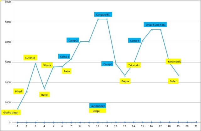
Altitude depending on distance

Altitude at Night

Daily Height Difference
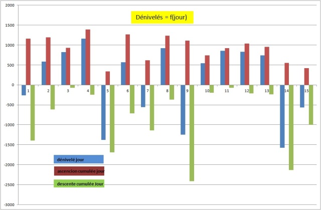
This year, the daily cumulated altitude differences are calculated from the GPS traces. The main difficulty of this trek consists in the ascents and descents for crossing the valleys.
GPS Traces et waypoints:
Traces are defined with a point for 30m to avoid the saturation of the GPS memory. They are in free access on Wikiloc, with some significant waypoints, indicated in this logbook. All Waypoints are given in an Excel sheet in GPS/tableur Spreadsheets
Our new GPS GARMIN ETREX 10 is great. It uses fewer batteries than the precedent: 2 AA approximately every 5-6 days. It can be linked with the computer to copy the traces and waypoints.
The waypoints on the excel sheet were corrected after the trek, where it was necessary. The distances between waypoints are on the other hand approximate. The daily distances are exact. Finally, and as usual, our paths are not necessarily the best. They can change in time, the collapses and the construction of new roads. All trekkers remain responsible for their own routes.
To be noted:
The new road after Kattike Ghat go by an unnecessary pass. It must be possible to by-pass it by going along the Irkhuwa valley, as it is indicated on the map (Jiri Pikey Peak 1:125 000).
We voluntarily avoided the center of Bung, by-passing it by the right.
We followed the indications on the map by going from Panggom to Taksindu via Bupsa. It’s a big mistake because this route requires half an additional day of walking in inconfortable ascent. Unless going to Lukla, the best is to come down directly towards Karikhola from Panggom. The track is physically visible, but absent on the map!
Logbook:
Friday 13th May, From Khandbari to Chalise (970m) wp K14
Awake 5h15, t=21°c, departure 7h15, Arrived 17h, 22km in 9h45, cumul ascent 1160 m, cumul descent 1398 m
This is not so simple to go out of a city by foot from a small track, even with the GPS. Our friends in Khandbari suggested to putting us on the good path. But it is a question of pride… We also want to escape in the early hours to walk as much as possible without rain. After some hesitations, we begin the big descent towards the Arun river. We join a track which has to connect Tumlingtar to the upstream of Arun (probably on the bank, opposite to Kattike, just before the monkey bridge which drives to this village).

We cross very beautiful villages and find sometimes small restaurants. A drizzle begins to fall by 9:30 am which stops also quickly. The way is pleasant and we lunch in Kattike, on the other bank of the Arun. We understand there would be 3 jeeps a day until Ghote bazar (one-way trip at 500 Rs ?). The only jeeps we see have their hoods wide open and they seem to have given up their ghost. We don’t moreover know from where they can come. We continue by foot and, as usual when a new road has been opened, the track is difficult to find. To follow the road would mean making considerable detours. 

We cross an unforeseen pass at 928m. We did not find any alternative, that one, in particular, which was to follow the left bank of the Arun then of the Irkuwa khola. We stop at Chalise. The first house, in the entrance of the small village, offers the hospitality. There is no guesthouse here. We take a basic shower with the small water pipe, in the garden. And this evening, it will be dalbath, of course. (800Rs with the overnight stay and Tibetan tea)
Saturday 14th May, from Chalise to Tendo (1372 m)
Awake 5h30, t=20°c, depart 6h30, Arrived 17h, 16.5km in 10h30, cumul ascent 1194 m, cumul descent 617 m
It rained a large part of the night and it is only at dawn that the drumming of drops on the roof sheet steel stopped. The weather is clear at the sunrise. We have a Tibetan tea for the breakfast and we finish the rests of the day before: bananas and rootis. The way rises at first regularly. It is necessary to be careful to cut the new road at the good moment to avoid endless detours. We quickly arrive to the village preceding Gothe bazar, Tabutar. This is, in fact, the terminus of the 4-wheeled vehicles. We are happy to leave this kind of civilization. There is a nice guesthouse in Gothe bazar, the first one since Kattike. After Gothe bazar, the way becomes a narrow track. We stop several times to take a tea or a mango juice in small taverns.
We arrive to Tendo under a flood of rain. Fortunately, we find a kind soul to welcome us: there is not of guesthouse in this village and before Phedi.
Sunday 15th May, from Tendo to Djobari (2215 m) wp62
Awake 5:50, t=18°c, departure 7:10, Arrival 12h, 4.2km in 4:50, cumul ascent 931 m, cumul descent 75 m
It rained all night long and it’s always raining upon awakening. We do not hurry. Furthermore, we are tired by the previous two days of walking. The rain stops during the breakfast (tea and biscuits). It takes less than one hour and a half to join Phedi where there is two lodges in the entrance of the village. We do not take the precaution to fill our bottles of water before the big ascent and we will have to beg water on the way. We arrive at Djobari early but we decide to take some rest in a small lodge the owner of which it is necessary to find before being able to settle down. We are rewarded for the efforts of the morning with a beer and biscuits for the lunch.
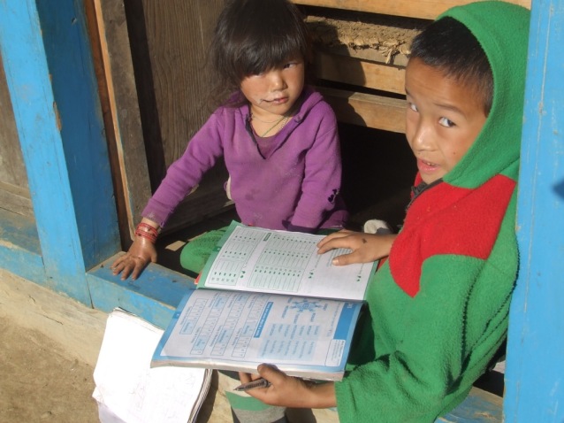
The school is in reconstruction close to the lodge. The damages are probably a consequence of the April, 2015 earthquake. Many houses are damaged, padlocked or in reconstruction on the road. The villagers assemble its frame while the children attend their class in a temporary building. The class is disrupted by our arrival and we are transformed into local and improvised entertainment.
Monday 16 May, from Djobari to Salpa (3357m) wp67
Awake 5:40, t=15°c, departure 7:20, Arrival 3:45, 8.4 km en 8h30, cumul ascent 1394 m, cumul descent 247 m
First change of batteries for the GPS. The weather is correct this morning and we take our time for the breakfast with tea and biscuits bought to the store of the lodge. I pay 1800Rs for all: night, beer, dalbath, apple spirit, biscuits, mango juice and tea.
The village extends in height and we discover another lodge, more centered, with a real restaurant. We’ll not find more water before Salpa as we pass by long crests and the soil becomes sandy.
At middle way (place called Kharka on the map), we go on by the right, according to the advice of several locals and against the indication of the GPS. This detour makes us pass by the lake while the map indicates a main way directly to Salpa. It has maybe disappeared in a collapse? A thunderstorm surprises us at the beginning of the detour and we just have time to protect ourselves in a hut-cowshed. We hesitate to return towards the abandoned village (Kharka) or to try our luck towards the lake to camp, less than a kilometer from there in theory. We cross an impressive rhododendrons forest. Some are still in bloom. The view must be magic in spring.
We have no more than one liter of water when we discover, instead of a lake, a totally dry basin on a sandy bed with some huts (WP65). It is almost 3 am. Impossible to stay. A local indicates that Salpa is just on the other side of an almost vertical pass. We decide to go. The sacred lake is on the other side of the pass, reached in half an hour. It is incised and offers no panorama. Some workers work on the arrangement of its sacred banks. The lack is invaded by mists and does not tempt us to establish a camp there.
We discover Salpa, based on a crest. The village seems abandoned and there is no tap water. Salpa seems to have for only vocation to welcome the pilgrims. There is fortunately an open building. The owner offers us the shelter in a very basic shed where will pile up porters and her family during the night.
Tuesday 17th May, from Salpa to Gudel (1975 m) wp70
Awake 5:45, t=6°c, departture 7:15, Arrival 3:45pm, 14.7 km in 8h30, cumul ascent 337 m, cumul descent 1691 m
The night was interrupted by noisy arrivals of porters. We gave up blanquets, openly sticky. The owner, remaining a businesswoman, asks us 1800Rs of which 1200Rs for the dalbath!
Alerted in the early hours by more or less harmonious sounds, we attend a procession leaving from the big gompa in front of our shelter, led by a young man who wears a feathers headdress . I am surprised, seeing the pilgrims taking him in video and in photos (I make nothing else).
Long life to all religiosities when they do not incite either to the hatred or to the violence!
It was not question of the slightest toiletry in Salpa and we stop near a torrent to wash ourselves and for a small laundry. Wp68. The sun is with us for our happiness. This hillside is also very bucolic, papered with rhododendrons.
A rusty panel indicates Sanam and an inhabitant recommends us to continue in this direction. We prefer to go on by the valley to avoid a new useless pass. The way in the valley is less taken and sometime more difficult to find. The weather remains clear until 2:30 pm, as a Chilean doubles us as a racing car. It is our first trekker in 4 days and even the first one since we are in Solu and Makalu.
A thunderstorm arrives while we discuss. Panchos, frequently used up to there, areuseless because of the violent wind. It is time to arrive to Gudel before being dipped. The lodge which opens to us, Kopila Guesthouse, is perfectly clean. Never seen at this point before!
Wednesday 18th May from Gudel to Khiraule (2539 m) wp72
Awake 5:30, t=14°c, departure 6:40, Arrival 5:30pm, 9.4 km in 10h50, cumul ascent 1264 m, cumul descent 712 m
Everything began correctly with a breakfast as worthy as in Khumbu. Sylvie is brutally struck by a tourista while we begin the descent. We stop in emergency for half an hour. The rhythm of the walking will feel the effects of it during the day. We abandon the main path to avoid the center of Gudel by going on the left (would be better to try by the right). The crossing of the small hamlets is very nice but the path often gets lost in the terraces of the fields. We ask several times for our direction to the inhabitants, a little bit surprised seeing us walking there…
We stop for the lunch in a magnificent lodge: Panch Pokhari Lodge wp71. We take our time (1:30) to appreciate this luxurious place. We are far from the Makalu basic stopping places. We complete our endless rise towards Khiraule, slowly and by enjoying the tranquillity and the bucolic charm of the region. A small paradise opens to us and we stop more often than to get back our breath, to take advantage of what the way offers.
We arrive late at the lodge. it is adjacent to a temple in the circular temenos, composed of manis and lined with old pines. Magnificent!
The night has felt when we go out of the dining room, fed of dalbath and raksi. The panorama, as far as go our looks, is papered with small lights, so many houses, as stars, uncountable. The place is silent and inhale the serenity. We didn’t rose for nothing.
The night is a bit expensive, 500Rs, but as we are near the Paradise, it doesn’t matter.
thursday 19th May, from Khiraule to Inkhu khola (1982 m) wp74
Awake 6am, t=8°c, departure 8am, Arrival 3:15pm, 8.3 km en 7h15, cumul ascent 615 m, cumul descent 1136 m
It rained a large part of the night after the sunny day of yesterday. This morning is cloudy and we have to join two impressive stupas which guard the pass. We cross fog patches. The descent towards Inkhu khola is difficult. We cross Nadjingsur, in a plateau, which possesses three correct lodges. We arrive to the bridge at about 3 pm and we have no courage to raise the 700m reaching Sibuje. We find a rustic lodge just after the bridge possessing a shower! (1800Rs for dinner, bed and breakfast)
The Inkhu khola gorges are spectacular. The weather is unfortunately very cloudy and showers begin to fall at 4pm.
Friday 20th May, from Inkhu khola to Panggom (2900m) wp78
Awake 6am, t=15°c, departure 7:30, Arrival 5:20pm, 7.1 km in 7h50, cumul ascent 1234 m, cumul descent 365 m
It rained all night long and it go on in the morning. Ponchos have never served so much! We stop to Sibuje in the fog ( wp75 ) for the lunch at 10:50 am. The ascent exhausted us while we are only at the middle of the way to the top. We refuel with a soup in noodles, an omelet and a tea (800Rs. These stops are so many opportunities to share the everyday life of the Nepalese families. A shower sticks us more than one hour. We leave in the fog. There are good lodges there ( wp76 ).
A shower surprises us again and we continue under the ponchos…
A panel indicates « Pangome Gompa » and we try to go there, against the indications of the GPS. We turn back because we have no idea where it can lead us. We will discover this Gompa on a height by arriving at Panggom. As the deviation leads to it, it was possible to go on the fork to pass by the gompa on the way to join Panggom.
The lodge (Himalaya Trekkers) which welcomes us is new and well maintained. It possesses even a hot shower! We are served with a correct dalbath and an excellent raksi with millet, » barli » and quince? Diuretic in any case! 2000Rs for the dinner the overnight stay and the breakfast.
A dance gets ready with brash young girls. We are informed but not invited 😉 In a so small village, a such concentration seems surprising. These girls are probably living in a hostel adjacent to the lodge. It would mean that they go to an Hillary school? His foundation created a lot of these schools in the region. In this case, we could assert that it is a big success.
Saturday 21th May, from Panggom to Jubhing (1656 m) wp 79
Awake 6:30, departure 7:30, Arrival 5pm, 13.1 km in 9h30, cumul ascent 1115 m, cumul descent 2416 m
We pick in our reserves for the breakfast because the manager has messages to send and does not have too much time for taking care of us … While we are already on the way towards Bupsa, she shows from a window, that another way go towards Taksindu. We do not take this advice into account because the map indicates only one way, passing through Bupsa. The descent is soon transformed into rather stiff, illogical ascent as we have to join the valley. Sylvie takes one foot in a root while she is sliding. All her leg holds her weight and that of her bag in twisting. The first pain blurred, all the leg remains painful. She decides to leave slowly and by limping. I take her bag. We are fortunately close to Bupsa.
The road towards Bupsa leads to Lukla and Namche. It is a big bend to go towards Taksindu because it is pointedly necessary to dive into the valley of Kharikhola. We stop in the first lodge, very clean. The owner gives us an anti inflammatory cream and recommends not to make anymore effort today. Meal 850Rs. Sylvie getting better, we leave towards Taksindu on the important track linking Jiri and Phaplu to Namche. The convoys of mules pass almost continously. The way is papered with stinking and slippery dung. It is sometimes necessary to push away animals with the stick not to be pushed aside. To complete the pleasure, it’s a Buddhist national holiday today. Repetitive speeches, spread by loudspeakers, accompany us a big part of the afternoon. We stop to Jubhing. Lodges, here, has no more the quality of those met since a few days.
Sunday 22 May, from Jubhing to Nunthala (2198 m) wp80
Awake 5:45, t= 17°c, departure 7:20, Arrivl noon, 5.7 km in 5h40, cumul ascent 741 m, cumul descente 192 m
The previous day cost us 1250 Rs for lunch and 1650 Rs for bed and dinner. The average of the spending is in average 25 – 26€/day
The sky is clear this morning and we can perceive some high summits of Khumbu. The walking begins with a little convenient descent in the dung of mules towards the Dudh khola. Then begin the ascent, under the sun, sawing our legs. But Sylvie’s knees gets better.
The batteries of the GPS are changed for the second time at 11:10 am.
We arrive to Nunthala for the lunch (magnificent Himalayan Trekker Lodge). The village is particularly beautiful and clean. We would almost imagine we are in Switzerland. People are smiling and it tempts us to stay. The decision is taken during the lunch: after noon will be a resting time before the next 4 days of ascent. We are go about in the main street and take back our strengths.
Monday 23th May, from Nunthala to Taksindu la (3053 m) wp DK01
Awake 5:30, t= 16°c, departure 6:50, Arrival 11:15, 5.7 km in 4h35, cumul ascent 926 m, cumul descent 70 m
Is Nunthala endowed of an Hillary School? Big buildings overhang the village, as we had seen in Panggom. We go up without any trouble by comparison with yesterday. The sun is softened by a light mist. The panorama is unfortunately partially filled by clouds. The view remains magnificent. After investigation in Taksindu, we decide to continue until Taksindu la where is a recent lodge and the starting point for Dudh Kund, the Milky Lake.
We are now in the mist and Sylvie would eat a chicken with her feathers (she says). A new free afternoon for rest in a very comfortable lodge.
Tuesday 24th May, from Taksindu la to Camp 1 (3884 m) wp 81
Awake 5:30, t= 9°c, departure 7:30, Arrival 15h15, 8.3 km en 7h45, cumul ascension 1037 m, cumul descent 210 m
The departure is in the fog. Sylvie grumbles because she don’t want to leave in this bad weather. I hope that it will get up with the ascent. The way is very bucolic and well marked . It crosses a beautiful rhododendrons forest in the first part which becomes mixed after. We have a lunch when two young Nepalese double us: they join a camp of high pastures. They are the only human beings that we’ll meet during these three days. Rain begins by 2 pm.
We see beautiful massifs of yellow rhododendrons, still with beautiful flowers at these altitudes.
We made more or less half of the path to Dudh Kund when we find a correct place for a camp. It is always raining and we settle the tent in these difficult conditions. It will be necessary to content ourselves with the remaining water from Taksindu la because we haven’t found any source on the path.
Wednesday 25th May, from Camp 1 to Dudh Kund pokhari (4626 m) wp 83
Awake 6am, t= 0°c, departure 7:30, Arrival 3:20pm, 9.7 km in 8h15, cumul ascent 954 m, cumul descent 237 m
The rain had stopped at night to start up again with renewed vigor. It is accompanied with gusts of wind then snow. This is the big storm. The temperature falls brutally. We are afraid that the tent flies away and that bags, protected by ponchos, fall in the ravine. I get up before the day rise to verify the installation. The spectacle is Dantesque with a moon quarter and some visible stars in patches of clear sky, and, far off, with the cleared big massifs, overhung by a strange black coat. I remove the snow accumulating on the double roof, making both walls contact themself. I go back to bed hoping that the storm will quickly stop.
When the weather calms down, the sky is totally cleaned. A carpet of snow recovers the surroundings. After the breakfast, Sylvie is not convinced to continue. I decide anyways to go on at all costs, now so close to the goal. She should come down easily to Taksindu. The perspective of the forest crossing makes her have a change of mind.
First water source at wp 82. Sylvie is particularly slow and I begin to doubt our capacities to reach to the lake today. I decide to carry her bag. I ascent on approximately 500m with 28 kg and some cramps will make me suffer at the stage!
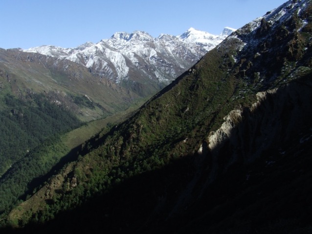
The weather quickly gets blocked with the rise of mists caused by the heat of the first sunrays. Snowing begins but there is no thunderstorm. The mist withdraws from time to time to make us perceive majestic summits and so close, a gigantic cliffs. We arrive, exhausted, to Dudh Kund. Surprised! There is no lake but an alignment of low walls. I forgot that the lake is further north. It is necessary to continue…
The lake is smaller than I thought. Its level lowered a lot as the various strata left on its banks show. The massifs appear by intermittence. We settle the tent on an small protected area of fine sand.
Thursady 26th May, from Dudh Kund to Taksindu la
Awake 6:00, t= 7°c, departure 9:00, Arrival 5:35pm, 17.6 km en 8h35, cumul ascent 554 m, cumul descent 2136 m
The mountains did not appear in the evening and it snowed this night. The temperature remains however too high to have a clear and dry time. We dry the bags and affairs in the shy sun rays morning. I walk to get the rare moments when the landscapes appears from the mist. The place is magnificent. I collect some old coins on the banks of the lake.
I take advantage of our stay to locate the possible passages to rise on a crest or on a summit. It will be a waste of time for this time: the weather is far too unstable to be able to continue. The weather quickly goes bad. We decide to come down, again in the fog, and occasionally in the rain. We are happy to seek refuge in our lodge of Taksindu la.
Friday 27th May, from Taksindu la to Phaplu (2490 m) wp 84
Awake 6:30, t= 14°c, departture 8:30, Arrival 1:30pm, 14.7 km in 5h, cumul ascent 421 m, cumul descente 997 m
We take our time this morning. The weather is sunny, even if the massifs are already in the clouds. We have no regret to have shortened our stay in altitude. The road from Taksindu, is carriageable, at least by tractors and motorcycles. It is necessary to pay attention not to leave the old track which is frequently cut, to avoid monstrous bends. The way crosses very attractive forests of hundred-year-old pines.
The trek ends to Phaplu, a little bit glaucous city, as all the border cities .
We book the return jeep in the lodge. Meeting at 5 am for a precise departure at 5:30 am.


