


Context:
We should be in Makalu in May, 2016. Rather than to return directly from Tumlingtar to Kathmandu, we plan a trek from Khandbari, East to North West to Salleri (return by jeep) or Phaplu (return by aircraft) by Phedi, Bung, Panggom, Taksindu.
Two segments are planned to be close to the high mountain: one leading to the base camp of Kongde (6093m) and one leading to Dudh Kund (Milky Lake) close to another small 6000.
The major part is situated at low altitudes under 3000m, in the Hills. We should have a beautiful view of the high massifs in the North from Kongde as well as from Dudh Kund ri if the ascents are feasible.
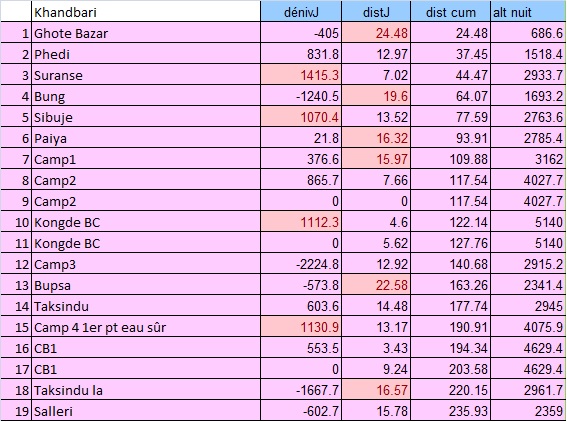
The distance to be traveled is important: 236 km on 19 days with an acclimatization day towards 4000m and the 2 explorations. It will be possible to eliminate a segment according to the difficulties found on the ground. The track towards Kongde is totally invisible on Google Earth. It will be necessary to follow the torrent leading to the base camp. On the other hand, the track to Dudh Kund is perfectly visible and recorded. The explorations to lead to points of view on the massifs to the North remain to be explored, in both cases.
Situation:

Click to enlarge
Timetable:
Altitude=f( Distance)

Altitude at Night:

Daily Difference of Altitude:

